billski
Active member
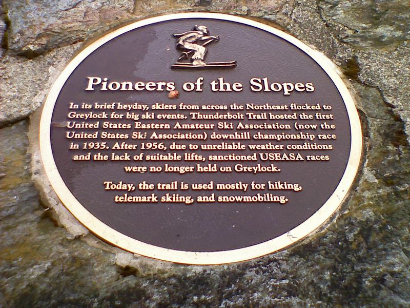
So I did a little bit of "course inspection" on Thunderbolt. Hiked it top to bottom.
This trail report is from a downhill skier's perspective, so I looked a bit differently at things rather than my normal hiking trail reports.
Impressions
- It looks like one damn fun course. It also looks like one damn hard course. Record time down is a little over 2 minutes.
- roughly 2300 vertical foot drop over about 2 miles. No stops, no trail merges, no terrain parks. You could really fly down this thing if your legs could sustain it. You could pickup some amazing altitude. Gadzooks.
- This thing is maintained. Like REALLY maintained. Recently (within this summer/fall) The brush had all been mowed down, all the saplings and protruding branches on the side and overhangs have been trimmed and cleared.
- sinkholes have been partially filled with brush and trees.
- It's wide enough - old-style, about 40 to 60 foot wide.
- It winds, it rolls.
- It's got water bars and some timber cross-trail to hold the snow.
- It's just one friggin drop, drop drop. The drop just doesn't stop.
- Nice warming hut for skiers on top. The wuffers wouldn't find it.
- It has a couple of 35-degree pitches. Man, the designer knew what he was doing.
The bottom was very narrow, it wasn't the original trail, it was relocated later. One place on the near the bottom relo will require poling/uphike (Chris, you there?) there's no way to get enough momentum on the turn to schuss it.
The hiking wasn't easy. I'm not talking about the pitch or effort. I'm talking about the trail as a hiking trail. This was designed as and maintained as a ski trail. It does not have all the gentrification you see in northeast hiking trails. Often, there is no trodden path, which is difficult when you've got a lot of leaves on a steep pitch. It's not blazed much, but it's fairly obvious where the trails goes (er, except in the dark, well, that's another story.) It's got a lot of lose rocks all over the place, which makes footing measured..
Downside, I suppose is the lousy weather that Mass. has been getting. So you'd have to watch for ice. Seemed to hold the snow well, last weeks event still had numerous traces near the top.
It was a nice opportunity to actually inspect a course - I'm usually flying down, stopping to take a couple pics. This gave me a much better sense of every turn and swoop. I'll post pics later, they're on my camera phone.
This was much more of a ski trail/slope than I imagined. It's right up there with the steeps at Stowe. I have read various reviews some call it tough, some call it "not too hard" to ski. It was another one of these trails I can't wait to get back and ski.
By the way, I picked up a Mountainsmith Approach 3.0 pack and this was it's inaugural hike. It was great. Requirements: Bigger than a standard daypack, tons of pockets and lots of technical features (loops, straps, fasteners). It is a great day pack when you want to carry a bit more than usual. I'm an explorer, so I tend to have extra garbage in my pack. More on that another time.
__________________
So here are the pics
Upslope Trailhead: http://www.iabsi.com/ski/Thunderbolt Trail/2008-nov 155.jpg The lower 1/4 was relocated decades ago and is more or less a hiking trail, not the original ski trail. Fairly well signed, but not many blazes.
http://www.iabsi.com/ski/Thunderbolt%20Trail/2008-nov%20157.jpg
where it joins with the orginal trail, much broader:
http://www.iabsi.com/ski/Thunderbolt Trail/2008-nov 162.jpg
http://www.iabsi.com/ski/Thunderbolt%20Trail/2008-nov%20167.jpg
The pitch improves at about 1/3 way up
http://www.iabsi.com/ski/Thunderbolt Trail/2008-nov 168.jpg
Notice how clear and void of obstructions the trail is. Lots of TLC on this trail.
Bridge. They said there were three bridges, but I only encountered one. Pitch improves further.
http://www.iabsi.com/ski/Thunderbolt Trail/2008-nov 170.jpg
I imagine pretty good speed at this point
http://www.iabsi.com/ski/Thunderbolt Trail/2008-nov 171.jpg
Some rough and tumble. Imagine the guys in the 1930s, 220cm wood skis, leather boots with straps... I am impressed
http://www.iabsi.com/ski/Thunderbolt Trail/2008-nov 172.jpg
Ski Trail junction
http://www.iabsi.com/ski/Thunderbolt Trail/2008-nov 173.jpg
Not a straight line to be found
http://www.iabsi.com/ski/Thunderbolt Trail/2008-nov 174.jpg
Filling in the blanks:
http://www.iabsi.com/ski/Thunderbolt Trail/2008-nov 176.jpg
Hang on to your hat!
http://www.iabsi.com/ski/Thunderbolt Trail/2008-nov 177.jpg
Oh Sh*)!
http://www.iabsi.com/ski/Thunderbolt Trail/2008-nov 178.jpg
Who said 35 degrees?
http://www.iabsi.com/ski/Thunderbolt Trail/2008-nov 180.jpg
Ride em Cowboy!
http://www.iabsi.com/ski/Thunderbolt Trail/2008-nov 181.jpg
Phew!
http://www.iabsi.com/ski/Thunderbolt Trail/2008-nov 183.jpg
check, check check!
http://www.iabsi.com/ski/Thunderbolt Trail/2008-nov 184.jpg
gasp
http://www.iabsi.com/ski/Thunderbolt Trail/2008-nov 185.jpg
http://www.iabsi.com/ski/Thunderbolt Trail/2008-nov 187.jpg
is that the start?
http://www.iabsi.com/ski/Thunderbolt Trail/2008-nov 190.jpg
Racer ready?
http://www.iabsi.com/ski/Thunderbolt Trail/2008-nov 195.jpg
3-2-1-GO!
http://www.iabsi.com/ski/Thunderbolt Trail/2008-nov 197.jpg
A/T from top of steep to summit. Like that white stuff.
http://www.iabsi.com/ski/Thunderbolt Trail/2008-nov 203.jpg
http://www.iabsi.com/ski/Thunderbolt Trail/2008-nov 229.jpg
http://www.iabsi.com/ski/Thunderbolt Trail/2008-nov 206.jpg
Scenic Adams, Mass.
http://www.iabsi.com/ski/Thunderbolt Trail/2008-nov 216.jpg
Nice Shelter for Hikers and Skiers
http://www.iabsi.com/ski/Thunderbolt Trail/2008-nov 218.jpg
http://www.iabsi.com/ski/Thunderbolt Trail/2008-nov 221.jpg
http://www.iabsi.com/ski/Thunderbolt Trail/2008-nov 222.jpg
Do you think the AT might need a crossing guard here? Rebuilt road.
http://www.iabsi.com/ski/Thunderbolt Trail/2008-nov 225.jpg
A/T, beginning of Thunderbolt from the roadside.
http://www.iabsi.com/ski/Thunderbolt Trail/2008-nov 226.jpg
http://www.iabsi.com/ski/Thunderbolt Trail/2008-nov 223.jpg
Wasn't sure what forum to post this in, so I'll cross-link to ski forum.