• Welcome to AlpineZone, the largest online community of skiers and snowboarders in the Northeast!

    You may have to REGISTER before you can post. Registering is FREE, gets rid of the majority of advertisements, and lets you participate in giveaways and other AlpineZone events!

Weather Dictionary

Joined
Sep 15, 2012
Messages
780
Points
16
Location
Boston
I'm going to try and compile a list of weather terms here so when people don't know some terms being thrown around, they can refer back to here. (Maybe someone could pin this?) Feel free to add some.

-Miller A Storm: A type of nor'easter. One primary low, often better snow for the coast rather than the ski areas.
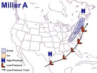
post-128-0-63137700-1290799635.jpg

-Miller B Storm: Another type of Nor'easter. One low dies inland and another one forms off the coast. Often rain at the coast and snow in the ski areas (My favorite type of storm)
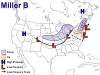
post-128-0-29313800-1290799740.jpg

-OTS: Out to Sea

-SWFE: Southwest Flow Event. Often starts off as snow in all of NE, changes to ice and rain at the coast, ice/snow inland. Warm air overrruns the cold
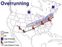
post-128-0-69068100-1290799866.jpg

-Clipper: Fast moving storm coming out of Canada. Sometimes can form a Miller B (Most extreme case, the Blizzard of 2005), or just lift into canada. Often brings good upslope snows in the Mountains

-Upslope Snow: Instablitiy combined with warm/cold winds creates snow showers over the Mountains. Can drop anywhere from dusting to feet of snow depending where you are. (Jay Cloud is an extreme example of this)

-Cutter/Inland Runner: Low tracks inland and doesn't become a Miller B. This means R@!n and Ice for us. Our worst nightmare.

-QPF: Total precipitation on the models


Models

-EURO(European): Very Reliable.
-GFS(American): Very Reliable, but often shows fantasy storms in the long range. Tread carefully outside of 5 days
-NAM: Godawful. Worst Model Out there, period
-GEFS: Meh, not great
-RGEM: Normally in the same class as the NAM, but has been pretty good this year actually
-SREF's: Tries to predict precipitation, not very good at it.
-CMC: The Canadian Model. (gah!) Could be worse than the NAM...

Again name some more if you know some.
 
Last edited:

mriceyman

New member
Joined
Jan 4, 2012
Messages
1,344
Points
0
Location
cnj
The euro hasnt been great this winter but i know what your saying


Sent from my iPhone using AlpineZone
 

catsup948

New member
Joined
Dec 6, 2007
Messages
1,026
Points
0
Location
Shelburne Falls, MA
Great idea! I like this thread.

Never trust the GFS outside 5 days but it is just so much fun!

UK MET

Navy Operational Global Atmospheric System known as NOGAPS. I really hope our navy does not uses this model.


I get excited looking a fantasy long range storms but nothing really matters until it starts snowing anyway. The computers are just reading data and producing possible scenarios. It gives a nice reference point to work with.


Sent from my SCH-I545 using Tapatalk
 

BenedictGomez

Well-known member
Joined
Jan 26, 2011
Messages
12,174
Points
113
Location
Wasatch Back
Models

-EURO(European): Very Reliable.
-GFS(American): Very Reliable, but often shows fantasy storms in the long range. Tread carefully outside of 5 days
-NAM: Godawful. Worst Model Out there, period
-GEFS: Meh, not great
-RGEM: Normally in the same class as the NAM, but has been pretty good this year actually
-SREF's: Tries to predict precipitation, not very good at it.
-CMC: The Canadian Model. (gah!) Could be worse than the NAM...

This is really kindof badly off in some parts.

The EURO has been absolutely terrible this winter. People only think it's the best because of its' Nostradamus performance the last few years, but the "upgrade" it received several months ago clearly through off it's ability to nail our northeastern winter storms. BIAS: Could be too far south

GFS - I wouldnt call it very reliable at all. It sees snowstorms far off like the Euro, but then often completely loses them, they vanish, then "finds" them again like inside of 72 hours, at which point every other model already has it and the track fairly nailed down. BIAS: Could be too far east and/or too cold.

The NAM is actually pretty decent as a short-range model, which is what it's mainly used for, though it grossly overdoes pcp. You cant try to use the NAM like you would a long-range model like the GFS or the EURO and then say it's "bad". That would be like entering a Lamborghini in a boat-towing contest and saying it's a bad car because it failed. Use the NAM inside of something like 48 hours and it's another tool in the toolbox IMO. Also, the SREF is the ensemble version of the NAM. BIAS: Could be too wet, like really too wet, as in, no we're clearly NOT getting 38 inches of snow.

CMC is not a model at all, it stands for Canadian Meteorological Center (this is major nit-picking and I know you realize this, but if the thread is for people to learn it's useful to point out). There are several Canuck models, and, for this winter at least, the Canadian has been hands down the best model at predicting northeastern winter storms so far. Of the Canuck models, look for the GEM-REG as it's a regional model and has the highest resolution. BIAS: Not really sure, though I do notice that when it is wrong, it can be spectacularly wrong.


EDIT: I'm going to add some known biases (achiles heel).
 
Last edited:
Joined
Sep 15, 2012
Messages
780
Points
16
Location
Boston
KU: Wicked big Nor'Easter. These are the ones that we remember for years to come ( Feb 2013, Boxing Day 2010, 2006, 2005, April fools day 1997, Jan 1996, 1978 etc...)


Sent from my iPhone using AlpineZo
 

4aprice

Well-known member
Joined
Mar 14, 2008
Messages
3,904
Points
63
Location
Lake Hopatcong, NJ and Granby Co
Correct me if I'm wrong but Miller A & B was derived from the direction the wind is blowing at the Miller Brewing plant (where ever that is) and the brewing process they use because of it. Of course for us it means either coming up the coast or jumping to and redeveloping off the coast. Usually good for us no matter what.

Alex

Lake Hopatcong, NJ
 
Joined
Sep 15, 2012
Messages
780
Points
16
Location
Boston
Correct me if I'm wrong but Miller A & B was derived from the direction the wind is blowing at the Miller Brewing plant (where ever that is) and the brewing process they use because of it. Of course for us it means either coming up the coast or jumping to and redeveloping off the coast. Usually good for us no matter what.

Alex

Lake Hopatcong, NJ

I don't know nor do I care, just as long as it's not Miller Lite!


Sent from my iPhone using AlpineZo
 
Top