- Resort or Ski Area
- Killington
- Date
- Jan 29, 2023
- Snow Conditions
-
- Packed Powder
Went to Pico on Sunday morning to knock a couple items off my bucket list:

Went up to the summit and started the day with a warmup run down all of KA, even the Lower section was open. I always enjoy the view from the top, which had been groomed:

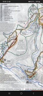
Then back up to the top to begin my trek to Killington. Turn left as you get off the Summit Express chairlift, then stay right at all junctions until you reach the unmarked interconnect trail.

When you reach the Summit Glades sign, before continuing to stay right, take a quick peek at the nice view down the 49er trail on your left:

View down 49er:

The interconnect trail is a short distance down Summit Glades, on skiers right below this tree island in the middle of the run:

Here on the Pico side, the entrance to the Interconnect trail is not marked, but it is very obvious, a wide groomed trail on skiers right heading back up the mountain. There are short uphill sections at the beginning and end of the Interconnect, but the main portion of the route is a smooth gradual groomed downhill from Pico to Killington, equivalent to an easy beginner green circle trail. There was no signage of any kind at the entrance, but despite not appearing on either Pico’s or Killington’s trail maps, the Interconnect trail is listed as an official uphill route from Killington to Pico and its open/closed status is listed under the “Uphill Travel” section of both mountains Conditions websites:
 www.picomountain.com

 www.killington.com
Although the Interconnect is a wide gradually sloping groomed trail, you will be leaving the resort boundaries, so be sure to take the usual precautions - travel in a group, fully charged phone, communicate your plan to someone, and check in regularly. Verizon coverage was OK along the route, but I recommend bringing a newer phone such as iPhone 14 that has emergency satellite coverage, just in case you get into trouble. You can read more about Killington’s uphill policies here:
 www.killington.com
One thing that is unclear to me is if the $49 Uphill Travel Pass (armband) is required to travel the interconnect in the direction I was going, downhill from Pico to Killington. I opted to save the money and plead ignorance if asked. At the start of the Interconnect, I happened to pass a ski patroller coming from Killington (only person I saw along the entire route) and gave him a friendly wave. He waved back and didn’t ask about my missing armband. YMMV.
Here’s the view looking up the short uphill section at the start of the Interconnect:

Looking back towards Pico from the top of the uphill section:

Looking at woods on skiers right I couldn’t spot any obvious shortcuts from Pico that would bypass the uphill section of the Interconnect:

edit: in r/icecoast, user vburnin described how the uphill start of the interconnect can be avoided:
The upper part can also be done but there has to be enough snow and you better be an expert+ at tree skiing. On skiers right at the start of the forty niner is the pico link hiking trail, it is extremely narrow, steep rocky and usually icy. I've done it a few times without taking off my skies but it probably takes almost as much time as just going uphill. Wouldn't recommend going off the trail either on either side are cliffs and dense trees
Continued in Part 2 …
Went up to the summit and started the day with a warmup run down all of KA, even the Lower section was open. I always enjoy the view from the top, which had been groomed:
Then back up to the top to begin my trek to Killington. Turn left as you get off the Summit Express chairlift, then stay right at all junctions until you reach the unmarked interconnect trail.
When you reach the Summit Glades sign, before continuing to stay right, take a quick peek at the nice view down the 49er trail on your left:
View down 49er:
The interconnect trail is a short distance down Summit Glades, on skiers right below this tree island in the middle of the run:
Here on the Pico side, the entrance to the Interconnect trail is not marked, but it is very obvious, a wide groomed trail on skiers right heading back up the mountain. There are short uphill sections at the beginning and end of the Interconnect, but the main portion of the route is a smooth gradual groomed downhill from Pico to Killington, equivalent to an easy beginner green circle trail. There was no signage of any kind at the entrance, but despite not appearing on either Pico’s or Killington’s trail maps, the Interconnect trail is listed as an official uphill route from Killington to Pico and its open/closed status is listed under the “Uphill Travel” section of both mountains Conditions websites:
Pico Mountain Snow Report - The Latest Updates On Pico Conditions
The Pico Mountain snow report offers the most current weather information and Pico conditions. Get up-to-date Pico Ski Resort snow conditions now.
Killington Conditions Report - The Latest Updates On Killington Conditions
The Killington conditions report offers the most current weather information and Killington conditions. Get up-to-date Killington Ski Resort snow & dirt conditions now.
Although the Interconnect is a wide gradually sloping groomed trail, you will be leaving the resort boundaries, so be sure to take the usual precautions - travel in a group, fully charged phone, communicate your plan to someone, and check in regularly. Verizon coverage was OK along the route, but I recommend bringing a newer phone such as iPhone 14 that has emergency satellite coverage, just in case you get into trouble. You can read more about Killington’s uphill policies here:
Snowshoeing Vermont & Killington Uphill Policy - Uphill Travel Program
Snowshoeing Vermont is on the rise. Killington offers an amazing uphill travel program. Learn about the Killington uphill policy, passes, routes & more.
One thing that is unclear to me is if the $49 Uphill Travel Pass (armband) is required to travel the interconnect in the direction I was going, downhill from Pico to Killington. I opted to save the money and plead ignorance if asked. At the start of the Interconnect, I happened to pass a ski patroller coming from Killington (only person I saw along the entire route) and gave him a friendly wave. He waved back and didn’t ask about my missing armband. YMMV.
Here’s the view looking up the short uphill section at the start of the Interconnect:
Looking back towards Pico from the top of the uphill section:
Looking at woods on skiers right I couldn’t spot any obvious shortcuts from Pico that would bypass the uphill section of the Interconnect:
edit: in r/icecoast, user vburnin described how the uphill start of the interconnect can be avoided:
The upper part can also be done but there has to be enough snow and you better be an expert+ at tree skiing. On skiers right at the start of the forty niner is the pico link hiking trail, it is extremely narrow, steep rocky and usually icy. I've done it a few times without taking off my skies but it probably takes almost as much time as just going uphill. Wouldn't recommend going off the trail either on either side are cliffs and dense trees
Continued in Part 2 …
Last edited:
")
