• Welcome to AlpineZone, the largest online community of skiers and snowboarders in the Northeast!

    You may have to REGISTER before you can post. Registering is FREE, gets rid of the majority of advertisements, and lets you participate in giveaways and other AlpineZone events!

AlpineZone Challenge 2012 Results - Steve Wright of Jay Peak

BigJay

New member
Joined
Mar 9, 2006
Messages
487
Points
0
Location
Jay Peak, VT
This layout is very similar to what the original west bowl expansion plan was prior to the construction of the Freezer. The Jay Peak brochure had a map showing the new west bowl, the Green Mtn Boys double being replaced with a detachable quad ending where the double did, and an Ullr's Chair. Ullr's Chair would have gone from Ullr's runout near the end of Deer Run and Kokomo to near where the future six-pack will terminate just above Northway. I just spent an hour digging through my old brouchures and trailmaps trying to find it with no success, but luckily the map is posted at new england ski history.

http://www.newenglandskihistory.com/skiareaexpansions/Vermont/jaypeak.php

They probably decided to go with the cheaper route of building just the Freezer instead of replacing the GMB double and building Ullr's chair. This also shows how lazy Jay peak has been with the west bowl expansion. It was on a map in a brochure 20 YEARS AGO. get the damn thing built or forget about it. It has been nothing but talk talk talk for 20 years. When they finally got some money, they built a waterpark instead.

I remember that old layout and it makes a lot of sens. Having a trail pod serving one area and then another lift serving a completely different area is how it's suppose to be.

The best of the best solution would be being able to eleminate that "traverse" lift... cause from an operation standpoint, it's a net loss. It doesn't allow people to ski and ride... and just caries them over from one area to the other... kind of like having gondolas between the Jet and the Tram between the townhouses.

I prefer the line proposed here that would stand over JFK. No need to cut down more trees, no need to open up new trails in between.

Putting less lifts in the West Bowl would preserve snow quality and improve the experience of being secluded from the rest of the big resort... until they put in a water park and a bunch of hotels there too... :)
 

fbrissette

Well-known member
Joined
Mar 19, 2012
Messages
1,672
Points
48
Location
Montreal/Jay Peak
I remember that old layout and it makes a lot of sens. Having a trail pod serving one area and then another lift serving a completely different area is how it's suppose to be.

The best of the best solution would be being able to eleminate that "traverse" lift... cause from an operation standpoint, it's a net loss. It doesn't allow people to ski and ride... and just caries them over from one area to the other... kind of like having gondolas between the Jet and the Tram between the townhouses.

I prefer the line proposed here that would stand over JFK. No need to cut down more trees, no need to open up new trails in between.

Putting less lifts in the West Bowl would preserve snow quality and improve the experience of being secluded from the rest of the big resort... until they put in a water park and a bunch of hotels there too... :)

I fully agree with the above. I hate the transfer lift and I prefer this old layout (first time I see it). On the other hand, even if they go ahead with the current layout, I am sure we'll find a way through the woods to get back to Kokomo's entrance without having to take the transfer lift.
 

BigJay

New member
Joined
Mar 9, 2006
Messages
487
Points
0
Location
Jay Peak, VT
When you can ride the bottom of tramside from the Jet... and ride the lower Jet after a run from the Flyer and Goat, you can pull that one off as well.
 

from_the_NEK

Active member
Joined
Jun 5, 2006
Messages
4,576
Points
38
Location
Lyndonville, VT
Website
fineartamerica.com
As much as I dislike transfer lifts, I think the transfer lift still comes into play here. Especially when upper mountain lifts on the main mountain are on wind hold (which NEVER happens at Jay :) ). The West Bowl should be the most wind sheltered area on the mountain. During windy days, when upper mtn lifts are on hold. The combination of lower mtn lifts would make accessing the West Bowl from Stateside possible (albeit 3 lift rides away). For all of the people staying in the Hotels, Condos, and Townhomes on the side of the mountain, this is important. You won't see me on those days. I'll either be at Burke, or on Skins headed to the top of Jay :).

Here are drawbacks of a cross over trail:

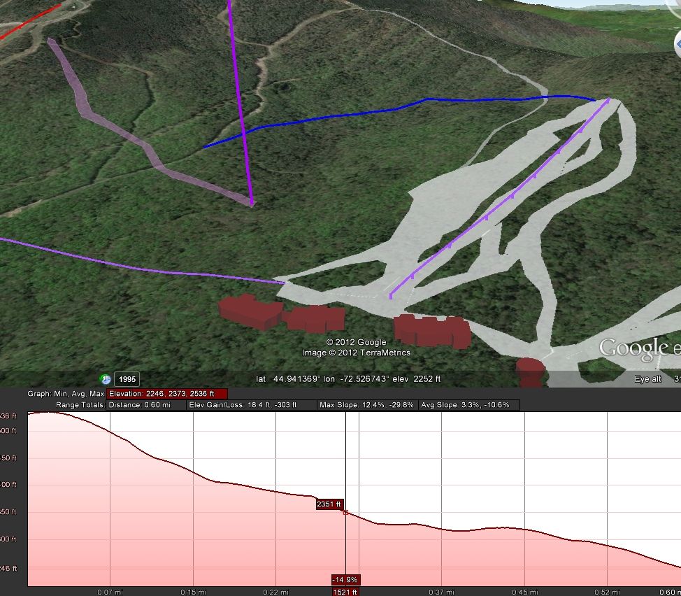
1. A connector trail from the top of the beginner pod of the West Bowl to the Ullrs Runout would result in a trail averaging 10.6% of slope for .6 miles.
2. Getting all the way back to Tramside would result in a 9.6% average slope for 1.4 miles. No thanks!
3. This connector trail would cross-cut the entire "Beaverpond-bowl" between West Bowl and Ullrs. This would suck for any unmarked glades that could/would be built off of the ridge line traverse.
4. You would have to take the lift servicing the beginner area (likely a slow quad) up just to get to the Cutback trail.

Riding the transfer lift would get you likely get you most of the way back to Tramside in about the same time as riding the beginner pod lift. And with out the 1.6 mile cross country ski adventure.


WestBowlCutback.jpg
 

BigJay

New member
Joined
Mar 9, 2006
Messages
487
Points
0
Location
Jay Peak, VT
@From_the_NEK: Any chance you were at last year's meeting regarding the State Side development plan?
 

BigJay

New member
Joined
Mar 9, 2006
Messages
487
Points
0
Location
Jay Peak, VT
There is a guy, Ludovic, who put together a whole bunch of conceptual drawings regarding the master planning of Jay Peak. Nice stuff as well. You guys would have had a blast debatting every little issue of every trail pod on the mountain!

His family has a condo on the mountain.

Too bad you missed them, i'm sure Steve would have been all ears.

Great stuff you're doing on Google Earth. Makes it very easily understandable for most people compare to a drawing/plan.
 

from_the_NEK

Active member
Joined
Jun 5, 2006
Messages
4,576
Points
38
Location
Lyndonville, VT
Website
fineartamerica.com
Google Earth is a really powerful tool. It is amazing how much easier it is to visualize an area when elevation and decent aerial imagery is included. I love elevation contour lines as well, so being able to overlay the master plan document (which has the contours) into Google Earth is a great conceptual planning tool.
Last night on my laptop at home, I just checked that West Bowl Flyover movie I created. Unfortunately, it just shows flying around the west bowl and all of the trails, lifts, and buildings that I have added are not visible. Apparently I would need Google Earth Pro ($600) to record the movie as I see it.
 

Steve@jpr

Industry Rep
Industry Rep
Joined
Jun 22, 2005
Messages
200
Points
0
Location
Vermont
Thanks.

Sorry I've been out of the pic--took a few days to head out of Dodge/south with the family before everything becomes unhinged up this way. More-so than usual I mean.

Fantastic thoughts on everything. I appreciate all of it. Suffice to say, none of what we currently have on the table is in stone. The creation of developmental forums, multiple feedback channels and surveys, etc.. is to try and collect as much information as we can prior to deciding what to build, where to build it and, as important, what not to add to the mix. While I don't agree with everything that's been offered here, I respect the fact that a strong connection to the resort is what's driving everything--right, wrong or indifferent. I've worked at enough ski areas to respect that and acknowledge that isn't the case at many spots. From this side of the fence, this fence at least, that's more important than anything.

Only thing I can take small issue with is the notion from XLER8R that Jay Peak is being, er, lazy in its approach to the West Bowl. I've mentioned, more than I care to mention, that folks should set their expectations to freeze with respect to WB and have eliminated coming-soon language from everything I could. Lazy suggests folks sitting around with their feet high which seems, at least to someone who hasn't struck that pose in a while, laughable. We can all agree to disagree on priorities--those that guests want to see and others that the leadership team feels make immediate sense but, please, let's try to refrain from the assumption that we're watching clouds drift up this way.

Again, I appreciate all of the input and my commitment, as it's always been, will be to continue looking at everything and considering things that I haven't previously considered. You may not always like the net decisions and we're likely to eff up now and again, but everything will be considered and examined before launching off in any particular direction.

steve


Figured out a work around for capturing video flyovers in Google Earth.


from_the_NEK

Active member
Joined
Jun 5, 2006
Messages
4,576
Points
38
Location
Lyndonville, VT
Website
fineartamerica.com
As always Steve thanks for the feed back.

I know there is a rollout plan for Jay's general build out. West Bowl is likely near the bottom of that list. Getting Tramside and Stateside "fixed up" first, should be and are the first priorities. These are parts of the resort that are already developed and the current building boom is building on what is already there to some extent. These areas are the first thing visitors see when they pull in. West Bowl is rather far removed from the rest of the resort. I can see why it doesn't make sense to expand there until everything else is done.

Has there been any discussion about creating a hike to, unpatrolled backcountry glade system out there? This would be similar to the hike to bowl out west where you have to pass through a gate at your own risk. It is roughly a 1.4 mile hike from top of Beaver Pond to Doll Peak. Versus a .9 mile hike over to Big Jay. Even though the West Bowl isn't as "extreme" terrain wise as Big Jay, it still holds a lot of snow and could be a very promotable experience (and less controversial than Big Jay). Linking up to the cross country ski terrain as an egress back to Tramside may be possible as well.
 

fbrissette

Well-known member
Joined
Mar 19, 2012
Messages
1,672
Points
48
Location
Montreal/Jay Peak
As always Steve thanks for the feed back.

I know there is a rollout plan for Jay's general build out. West Bowl is likely near the bottom of that list. Getting Tramside and Stateside "fixed up" first, should be and are the first priorities. These are parts of the resort that are already developed and the current building boom is building on what is already there to some extent. These areas are the first thing visitors see when they pull in. West Bowl is rather far removed from the rest of the resort. I can see why it doesn't make sense to expand there until everything else is done.

Has there been any discussion about creating a hike to, unpatrolled backcountry glade system out there? This would be similar to the hike to bowl out west where you have to pass through a gate at your own risk. It is roughly a 1.4 mile hike from top of Beaver Pond to Doll Peak. Versus a .9 mile hike over to Big Jay. Even though the West Bowl isn't as "extreme" terrain wise as Big Jay, it still holds a lot of snow and could be a very promotable experience (and less controversial than Big Jay). Linking up to the cross country ski terrain as an egress back to Tramside may be possible as well.

It would only require minimal work. Access is already provided by the long trail. Only minimal thinning (no downing of big trees) would be needed to provide a great downhill back-country experience. A small crew working for a couple of weeks could easily thin out a large area. Heck, I would gladly volunteer a few days to help out. Small cost, large potential reward. Heck, it would be worth it just to quiet down quite a few people about the West Bowl delays.
 
Joined
Sep 22, 2010
Messages
161
Points
16
Location
The Hinterlands
It would only require minimal work. Access is already provided by the long trail. Only minimal thinning (no downing of big trees) would be needed to provide a great downhill back-country experience. A small crew working for a couple of weeks could easily thin out a large area. Heck, I would gladly volunteer a few days to help out. Small cost, large potential reward. Heck, it would be worth it just to quiet down quite a few people about the West Bowl delays.

+1000 to that. I had exactly the same thoughts when I read NEK's post earlier but did not have time to answer. With a backcountry access trail, those of us that really want to ski the West Bowl (but are a bit lazy) could do so AND, of course, provide positive feedback to Bill, Steve, Walter and the gang. Heck, I'll volunteer to do a blog post about it!;-)
 

BigJay

New member
Joined
Mar 9, 2006
Messages
487
Points
0
Location
Jay Peak, VT
Oh yeah, we should just let people go "paul-crazy" on just "thinning" a large area of land...

I'm all up for a faster pace on the WB... but having volunteers thin out a large area isn't the best way to do it. Unless Jay has all the right permission to start "maintaining" the area and already have a clear plan of what the actual layout would be... Ride out there and enjoy it has is. Make the effort of skinning out there and skinning out of there. You'll see, there are a few very good lines already... but you'll need to work for it.

Also, it brings me to the subject of trail design. I like the rendering of google earth and all those fancy drawings... but i believe each of these points on the map should be surveyed in order to catch the particular features on the natural landscape. When we plan for bike trails, we use all the same fancy map to show the general proposal for trail corridor. We never know what the final product will look like until we start laying some flagging tape around... and then pin flat an actual trail alignment. I hope that ski trails, especially when it involves natural ski trails and glades, are planned that way as well. A rock face, a roller or cliff line doesn't show on a map and we need to be able to take advantage of that. They're call positive and negative control points.

When it comes to ski boulevards and highways, the excavator can carve anything... especially with a bit of dynamite... and that's a bit sad to see when you think of how pristine the land use to be and that careful trails planning would have probably saved a bunch of these natural features.
 

fbrissette

Well-known member
Joined
Mar 19, 2012
Messages
1,672
Points
48
Location
Montreal/Jay Peak
Oh yeah, we should just let people go "paul-crazy" on just "thinning" a large area of land...

You think Jay Peak would not be happy with a bunch of us roaming free with chainsaws in the West Bowl ???

Seriously, I was thinking about a Jay Peak-led operation, with proper permits, over the planned trails, to allow for better skiing until the lifts are put in place. I think this would be a good marketing tool for Jay.
 

kingdom-tele

New member
Joined
Mar 23, 2006
Messages
618
Points
0
Location
Newport Center, VT
Big Jay, natural features and "intermediate" skiing don't mix.

Carve it up. Get as much sun and wind exposure you can. The more dynamite the better.

People hike for skiing? What a waste of time, how many runs can you get in a day? Won't the hiking make you to tired to ski. For me its a complete waste of time unless I can get 15 -20 quality cruising runs.

Maybe a rope tow or some kind of people mover can be installed along the long trail. The magic carpet has a cover that works well, maybe they could enclose it.
 

BigJay

New member
Joined
Mar 9, 2006
Messages
487
Points
0
Location
Jay Peak, VT
People hike for skiing? What a waste of time, how many runs can you get in a day? Won't the hiking make you to tired to ski. For me its a complete waste of time unless I can get 15 -20 quality cruising runs.

Better snow conservation... and people drink more beer at the bar.

A bar and a magic carpet = problem solved.
 
Top