billski
Active member

Welcome to AlpineZone, the largest online community of skiers and snowboarders in the Northeast!
You may have to REGISTER before you can post. Registering is FREE, gets rid of the majority of advertisements, and lets you participate in giveaways and other AlpineZone events!

| RECREATIONAL FORECAST NATIONAL WEATHER SERVICE BURLINGTON VT 230 PM EST SAT DEC 28 2013 .THE HIGHER SUMMITS FORECAST FOR THE GREEN MOUNTAINS OF VERMONT... .TONIGHT...SUMMITS OBSCURED IN CLOUDS. A SLIGHT CHANCE OF VERY LIGHT FREEZING DRIZZLE AFTER MIDNIGHT. LOWS IN THE MID 20S. WEST WINDS 15 TO 30 MPH. WIND CHILL VALUES IN THE SINGLE DIGITS ABOVE ZERO. .SUNDAY...SUMMITS OBSCURED IN CLOUDS. SNOW OR A CHANCE OF RAIN IN THE AFTERNOON. HIGHS IN THE MID 30S. SOUTHWEST WINDS 15 TO 30 MPH. .SUNDAY NIGHT...SUMMITS OBSCURED IN CLOUDS. SNOW OR RAIN UNTIL MIDNIGHT...THEN A CHANCE OF SNOW AFTER MIDNIGHT. LOWS AROUND 20. SOUTH WINDS 5 TO 15 MPH...BECOMING WEST AT 15 TO 30 MPH AFTER MIDNIGHT. WIND CHILL VALUES IN THE SINGLE DIGITS ABOVE ZERO AFTER MIDNIGHT. .MONDAY...CLOUDY IN THE MORNING...THEN BECOMING PARTLY SUNNY. A CHANCE OF SNOW SHOWERS. HIGHS AROUND 20. TEMPERATURES FALLING TO AROUND ZERO IN THE AFTERNOON. WEST WINDS 25 TO 40 MPH. WIND CHILL VALUES IN THE LOWER 30S BELOW ZERO IN THE AFTERNOON. |


Does anyone know if it will snow all day at Mountainsnow tomorrow Sunday the 29? I go if snow not rain is forecasted..I looked at NOAA for West Dover and see some rain but MT snow facebook page saids heavy snow I go for that.
I'd trust NOAA's forecast for the area A LOT more than Mountainsnow's propoganda from their website and Facebook page My read is that it's gonna probably rain tomorrow afternoon, changing to snow after dark tomorrow night. Ski on Monday if you can.
I'm eyeing Mt. Wash Valley for Monday.
Going to be a total elevation dependent storm anywhere over 2000 feet may do well with this one. Air mass is yucky for late December though. Bring on some luck and help from the snow gods!
Sent from my SCH-I545 using Tapatalk
Get out Monday, high prices and all.
Odd that so few people have been making sacrifices to Ullr this year. It's no wonder we had such a deluge of waterNo point in leaving your old skis and boards in the basement to rust. Do you part today.

Looks like you have no choice. Logoff and head out!Looking good for my first ever day riding in Maine!
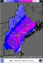
As a result of much procrastination, here's a first cut at the Snow forecast map with ski areas annotated. Crude, but it works. I'm going to try and figure out how to overlay the annotations on future maps so I can get out and ski. Enjoy!
View attachment 9991
btw, I figured out how to do an overlay. Now I'll clean it up and keep it for the next storm. I'll do one for VT too. This is going to help me circumnavigate ski safaris during a storm!
Since I am really only doing this for myself (and you guys get the breadcrumbs) there are several resorts that simply aren't on my radar this year. I'm using it real time to ID where I'm going this storm. Don't forget, those numbers are valley numbers - the peaks most likely will have more. I've got a community ski safari planned for the next two days. Nobody wants to come, but they sure like to read my reports!Good Work Bill! Really informative. FYI you forgot sunapee;-)
Since I am really only doing this for myself (and you guys get the breadcrumbs) there are several resorts that simply aren't on my radar this year. I'm using it real time to ID where I'm going this storm. Don't forget, those numbers are valley numbers - the peaks most likely will have more. I've got a community ski safari planned for the next two days. Nobody wants to come, but they sure like to read my reports!