• Welcome to AlpineZone, the largest online community of skiers and snowboarders in the Northeast!

    You may have to REGISTER before you can post. Registering is FREE, gets rid of the majority of advertisements, and lets you participate in giveaways and other AlpineZone events!

End of paper trail maps?

jimk

Well-known member
Joined
Sep 1, 2012
Messages
1,803
Points
113
Location
Wash DC area
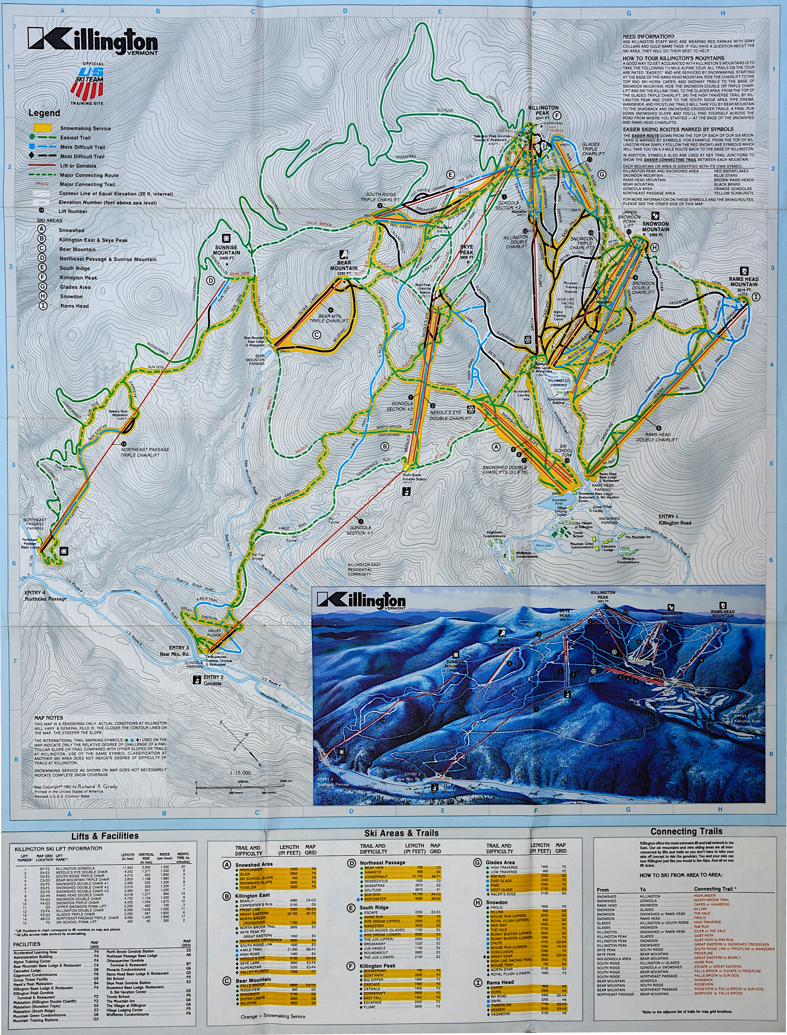
I recently stumbled onto the 3D ski area maps on the IKON pass website. They are kind of fun to fool around with (at home), especially to navigate around a big resort. Here's a link to the one for Killington: https://www.ikonpass.com/en/destinations?map=Killington

I too loved trail maps as a youngster. My older brothers plastered a wall in our house with trail maps they'd collected from around the USA. As a teen I used to stare at those and fantasize. Geography was my major in college. Now I've been to about 100 ski areas. I'll still grab a map whenever I ski a place I haven't been to in a while.
 
Last edited:

tnt1234

Well-known member
Joined
Sep 12, 2014
Messages
1,492
Points
48
My seven year old tonight. He rearranged his ski map bulletin board to make room for the Loon trail map he will pickup on Friday. We are starting our season there.

Vail back to offering print maps again?

I really hope so. Collecting trail maps is such a thrill for children
awesome!

Children? I love collecting train maps and I'm 54!
 

deadheadskier

Moderator
Staff member
Moderator
Joined
Mar 6, 2005
Messages
27,970
Points
113
Location
Southeast NH
This was a mistake. Finally feel comfortable sharing my James Neuhues book with my son without him trashing the book.

Mind = Blown! 🤯

I think I just watched my retirement age advance about a decade. 😐 "Daddy when are we going here? What about this big, big, one! I really want to go. What are we doing next weekend?" (in reference to Whistler).

IMG_20221203_081851350_HDR.jpg
 

Ski2LiveLive2Ski

Active member
Joined
Mar 20, 2013
Messages
648
Points
43
I often print my own and highlight the open trails. Often worth doing to decide where to go as trail names that separately title every 50 yds of trail make it difficult to visualize what is open based on trail count or even lists of what is open.
 

soposkier

Member
Joined
Jan 17, 2010
Messages
475
Points
18
This was a mistake. Finally feel comfortable sharing my James Neuhues book with my son without him trashing the book.

Mind = Blown! 🤯

I think I just watched my retirement age advance about a decade. 😐 "Daddy when are we going here? What about this big, big, one! I really want to go. What are we doing next weekend?" (in reference to Whistler).

View attachment 55200
I have been grabbing trail maps while I can. My 5 year old loves looking at them. Used to love going to the ASC resorts in the late 90s/early 2000s and grabbing all the maps that they seemed to have in the lodge.
 

urungus

Well-known member
Joined
Dec 1, 2016
Messages
1,815
Points
113
Location
Western Mass
Near the start of this season, I was told at Mt Snow that they don’t print paper maps anymore. But when I went this week sure enough they had a 2022-2023 printed map available. So I am now at 100% availabilty of paper maps this season.

Weak effort by Bousquet, though:
* washed out inkjet printing on 8.5x11 copy paper
* doesn’t say Bousquet anywhere
* leftmost portion of trail map is cropped out
* printed in portrait mode instead of landscape, so there are large white bars on top and bottom

IMG_5452.jpeg
 

doublediamond

Active member
Joined
Dec 22, 2013
Messages
453
Points
28
Every place I’ve been to has plenty of maps around other than Vail properties which removed maps with COVID to save a buck. More example of the McDonalds skiing at Vail.
 

BodeMiller1

Well-known member
Joined
Mar 7, 2022
Messages
1,703
Points
63
Location
Barre, VT
It's so much easier using a physical map than pulling out a cell phone and looking at the little screen, dealing with the touch sensitivity with gloves, and all that.
A paper trail map and a compass is the way to go. It helps if you can use the compass to orient the map to the mountain. This is a good skill and can get you out of trouble when lost wether in a car or in a boat, on a hill on in a moat.

Dead reckoning navigation.
 

ceo

Active member
Joined
Apr 1, 2009
Messages
393
Points
28
A paper trail map and a compass is the way to go. It helps if you can use the compass to orient the map to the mountain. This is a good skill and can get you out of trouble when lost wether in a car or in a boat, on a hill on in a moat.
I would never reply on a ski area trail map for navigation when lost in the woods. Most of them, particularly for larger resorts, are wildly distorted so as to fit all of the trails onto one map.
 

thetrailboss

Moderator
Staff member
Moderator
Joined
Jun 4, 2004
Messages
32,456
Points
113
Location
NEK by Birth
I would never reply on a ski area trail map for navigation when lost in the woods. Most of them, particularly for larger resorts, are wildly distorted so as to fit all of the trails onto one map.
Yeah, the poster is blurring the lines between two different types of map. A topographic map (now rarely used by ski resorts for public reference) and a reference map, such as a graphical representation of the ski area (what IS used). Almost all of this thread is talking about reference maps. Back in the day many areas (Killington being the most obvious) would print topographical maps, but people nowadays do not understand how to read them as easily.

Killington Map, 1982 (hybrid of topographical WITH a small reference map):

zv6d385qj7za6qtnl3oq0vt07qhl.jpg


Killington 2022 Map (reference map only)

wegu9p2txk3cl880726g71b9ot8s


SOURCE: skimap.org
 

BodeMiller1

Well-known member
Joined
Mar 7, 2022
Messages
1,703
Points
63
Location
Barre, VT
I would never reply on a ski area trail map for navigation when lost in the woods. Most of them, particularly for larger resorts, are wildly distorted so as to fit all of the trails onto one map.
I would never carry a cell. They're too heavy and bulky. I only carry a paper trail map when at a place I'm not familiar with. The paper maps always tell you where the bars are. This can be vital.
 

2Planker

Well-known member
Joined
May 16, 2007
Messages
1,492
Points
113
Location
MWV, NH
I would never carry a cell. They're too heavy and bulky. I only carry a paper trail map when at a place I'm not familiar with. The paper maps always tell you where the bars are. This can be vital.
Jeez. We couldn’t find a map at Stowe, SB or Jay in March last year. Most places only print so many, and when they’re gone, they are gone
 
Top