• Welcome to AlpineZone, the largest online community of skiers and snowboarders in the Northeast!

    You may have to REGISTER before you can post. Registering is FREE, gets rid of the majority of advertisements, and lets you participate in giveaways and other AlpineZone events!

First Snowfalls, Upcoming weather and Storms of winter 2023-2024. Storm snow totals, Observations and Predictions?

MidnightJester

Active member
Joined
Oct 7, 2011
Messages
936
Points
43
Maybe the KS effect is real...

And there is potential after this weekend for sure.
Next week was have 2 good possible shots at SNOW from the new Storm systems forming and more SNOW coming to the Northeast soon due to the Locked in COLD!
Around next Tuesday(1/16/24) and Friday(1/19/24) we have the makings off SNOW, SNOW and more SNOW as in 2 Rounds of (6"+) from each new storm system

This is a good chance to bury the Sunday/Monday frozen base by a Foot or more of fluffy snow : )
 
Last edited:
BenedictGomez

Well-known member
Joined
Jan 26, 2011
Messages
12,347
Points
113
Location
Wasatch Back
it will get very cold on backside with straight west winds and completely open Great Lakes. Open like they are in Nov and early December.

I used to love "wind monitoring" because Plattekill occasionally really benefits from lake effect snow, which most people dont realize given how far away it is from the Great Lakes, but there are times when 10" can dump there in a linear stream when it barely snows elsewhere = phenomenal.
 

BenedictGomez

Well-known member
Joined
Jan 26, 2011
Messages
12,347
Points
113
Location
Wasatch Back
You're getting the goods in UT as well though!

10.5 inches sor far at my house right now, and it's supposedly not really going to stop until sometime on Sunday!
Woke up this morning and it sounded like you were approaching the front lines in Nam', which I still havent gotten used to, but TBH I love it.
 

RH29

Active member
Joined
Nov 23, 2021
Messages
325
Points
43
Jay Peak, VT -- 14/81 12" (48hrs) -- "wow"19/81 trails(11"-13"(24hrs))
Worth noting that the Jet pod was closed today for wind and the stuff off Montrealer is under snowmaking.

Jet, Haynes, Hotshot Derick, UN and Willard have been open. Kitz, Kitz Woods, Montrealer, and Purgatory open up tomorrow. Village Lift, serving Raccoon/Grammy Jay, open tomorrow. So 34/81 or so for the weekend and probably more stuff off the Flyer following the next storm.
 

kingslug

Well-known member
Joined
Dec 30, 2005
Messages
7,079
Points
113
Location
Stamford Ct and Stowe
10.5 inches sor far at my house right now, and it's supposedly not really going to stop until sometime on Sunday!
Woke up this morning and it sounded like you were approaching the front lines in Nam', which I still havent gotten used to, but TBH I love it.
3 to 5 feet predicted by Sunday night
 

drjeff

Well-known member
Joined
Jan 18, 2006
Messages
19,315
Points
113
Location
Brooklyn, CT
See....but...
I won't talk about our forecast...
My wife and I are just waiting for our son to ask if he can reschedule his flight home this coming Sunday to later next week (he doesn't start his semester back up until Monday the 22nd)? So he can keep enjoying this cycle of storms!
 

drjeff

Well-known member
Joined
Jan 18, 2006
Messages
19,315
Points
113
Location
Brooklyn, CT
Worth noting that the Jet pod was closed today for wind and the stuff off Montrealer is under snowmaking.

Jet, Haynes, Hotshot Derick, UN and Willard have been open. Kitz, Kitz Woods, Montrealer, and Purgatory open up tomorrow. Village Lift, serving Raccoon/Grammy Jay, open tomorrow. So 34/81 or so for the weekend and probably more stuff off the Flyer following the next storm.
College races up at Jay this Sat/Sunday (that's where my daughter is heading with her team Friday afternoon...)
 

MidnightJester

Active member
Joined
Oct 7, 2011
Messages
936
Points
43
Worth noting that the Jet pod was closed today for wind and the stuff off Montrealer is under snowmaking.

Jet, Haynes, Hotshot Derick, UN and Willard have been open. Kitz, Kitz Woods, Montrealer, and Purgatory open up tomorrow. Village Lift, serving Raccoon/Grammy Jay, open tomorrow. So 34/81 or so for the weekend and probably more stuff off the Flyer following the next storm.
I would almost believe the new Owners are more trail conservative and were leaving possible open trails as closed to aid in building a natural laid base to last longer once Snow fell more and once Temperatures swung into Snowmaking territory for long term.
 

Smellytele

Well-known member
Joined
Jan 30, 2006
Messages
10,112
Points
113
Location
Right where I want to be
Base of the loaf ain’t good though…
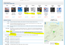
Saturday
Rain, snow, freezing rain, and sleet before 3pm, then rain and snow likely between 3pm and 4pm, then snow likely after 4pm. High near 36. Windy, with an east wind 20 to 30 mph becoming south in the afternoon. Winds could gust as high as 45 mph. Chance of precipitation is 100%. New snow and sleet accumulation of 3 to 5 inches possible.

Drive could be interesting but we know about your driving escapades…
 

KustyTheKlown

Well-known member
Joined
Mar 1, 2013
Messages
5,460
Points
113
Location
Brooklyn
im holding loaf to sunday, so hoping the backside brings softness. staying in gorham and planning the river saturday to stress less on the road
 

MidnightJester

Active member
Joined
Oct 7, 2011
Messages
936
Points
43
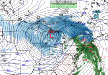
Its winding down to the starting time for Storm#3(Snow,Sleet,RRrrr) this weekend. Thankfully its looking like another Snow-base net gainer for more Northeast Ski mountains then not this MLK weekend. Beware a possible Sunday/Monday hard glaze & freeze-over for Ski mountains and Iced roads!! (FREEZER FOR 2 WEEKS-14 days & nights Below freezing straight most ski mountains)
8:36 starts the Northeast


DCT_SPECIAL48_1280x720.jpg


Best SNOW-HUNTING to all who venture out this weekend : )~
 
Last edited:

BenedictGomez

Well-known member
Joined
Jan 26, 2011
Messages
12,347
Points
113
Location
Wasatch Back
the gfs shows it colder

I havent looked at this storm at all, and hope it works out, but as an FYI based on your above comment, every model has its weakeness, and a known issue with the GFS with winter precipitation is it tends to come in colder than the other models. If the other models are all colder as well, you're probably G2G, but if the GFS is a cold outlier, it can often be a warning sign IMO.
 

KustyTheKlown

Well-known member
Joined
Mar 1, 2013
Messages
5,460
Points
113
Location
Brooklyn
I havent looked at this storm at all, and hope it works out, but as an FYI based on your above comment, every model has its weakeness, and a known issue with the GFS with winter precipitation is it tends to come in colder than the other models. If the other models are all colder as well, you're probably G2G, but if the GFS is a cold outlier, it can often be a warning sign IMO.

NAM at 45 hours. all blue in the next 3 slides too. on the line. but blue.


1704993334422.png
 
Top