Abubob
Well-known member
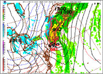
I know it’s long range but it’s the first possibility for heavy snow for northern New England.

Welcome to AlpineZone, the largest online community of skiers and snowboarders in the Northeast!
You may have to REGISTER before you can post. Registering is FREE, gets rid of the majority of advertisements, and lets you participate in giveaways and other AlpineZone events!
That looks like r$&n though for most of NE.Gettin’ better.
It does. But still snow in VT and Maine border.That looks like r$&n though for most of NE.


Wait a week maybe.If you don’t like the weather, wait a minute….


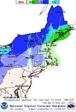
Nope. Too much wet stuff. Make it ALL SNOW. And then show again.


 www.facebook.com