Boston Bulldog
Member
What we know right now:
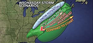
1.A storm will be tracking across the Southern US bringing plenty of gulf moisture with it.
2. Energy is streaming across the northern jet stream and if it arrives at the right time, it will help guide the low up the eastern seaboard.
3. Cold air will be limited, snow will be most likely confined to north and west of 495 (Not that there's a problem with that:-D) If the coastal low does form, the possiblity a cold backside band could deliver snow to the Metro area.
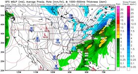
4. The Euro and the GFS have been 75% onboard with this storm occurring, but there still is high uncertainty.
What is still uncertain
1. Will the two pieces phase in time. If the northern energy races down to the Great Lakes region too fast, the cold dome behind it will push the southern system out to sea. If this occurs there obviously will be no widespread snow (There will be up-sloping in the Greens due to the cold blast just after T-day however)
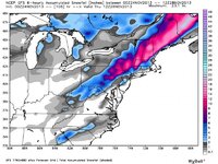
2. How strong will the storm get. Some model runs have been indicating a strong storm dumping a foot plus over the interior, all the while forming a cold sector on the backside, dumping an additional half a foot on ski country and allowing snow to reach the Boston area. Other solutions are saying that a quick slug of mousture could stream into the area delivering a quick punch of heavy wet snow, around 6-10 inches. This would occur if the storm is weaker, a solution that has been portrayed by the GFS.
3. Where the rain snow line will be located. It could range anywhere from the Lake Sunapee region all the way down to Metro Boston. The farther south the line, the stronger and colder the storm is.
There is still plenty to sort out in the coming days. It could be a whiff or ski country could jackpot. We will know in the coming days. Despite all of this uncertainty another cold blast will follow for next weekend, giving great snowmaking weather for all (that is if the wind cooperates).


