Better than the old Rust Ridge Cripple at Killington:
View attachment 7512
Yeah that is true! RIP South Ridge Triple!
Welcome to AlpineZone, the largest online community of skiers and snowboarders in the Northeast!
You may have to REGISTER before you can post. Registering is FREE, gets rid of the majority of advertisements, and lets you participate in giveaways and other AlpineZone events!
Better than the old Rust Ridge Cripple at Killington:
View attachment 7512
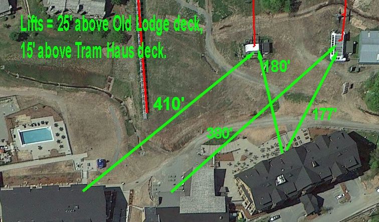
Wow, why didn't they place the base terminal closer? That is a crazy walk from the lodge! Does building code for their multi-story fancypants swankass lodge prevent them from building the lift closer? I'm sure going to enjoy walking across a ski trail in which skiers are maxing out their speed to make the Jet traverse without having to skate much. :roll: I feel bad for the beginners and low intermediates having to hike up to the Taxi Quad. Ridiculous.
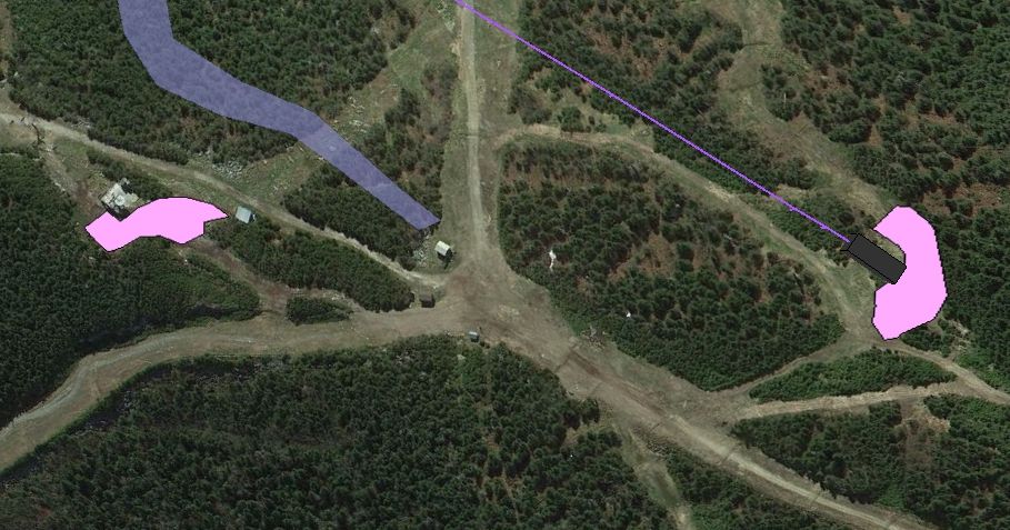
NEK... do those lines around Power Line and Liftline mean they are going to widen both routes? It makes sense to widen Powder Line for a 6 pack but why Liftline?
My main concern is that the unload area and trails will be too tight and narrow for a six pack lift. The trail leading down towards JFK looks steep enough so that it will become a skating rink leading on to Northway. I don't see why moving the lift line is necessary, the current location of the Bonnie works well and has a nice large unload area. This new alignment seems to be more exposed to wind and has a tighter unload area with skier traffic issues. With the only benefit of the new alignment being access to the JFK and Ullr's side of the mountain, which you cannot lap from this new lift anyway.
I think that FTN is actually Burke/Jay's engineer/architect in disguise....
Nice graphics.

Hey! I'm getting paid BIG bucks for this.
I'll agree with Riv on this one. The unload area of the new lift is going to be pretty large since they are cutting back into the mountainside quite a bit. And then there are three primary trails to move traffic away. The Connector with Northway, St George's Prayer, and the Power Line (liftline) itself.
(As Noted by Riv: they are going to have to rename Lift Line (trail where the Bonneventure is) to avoid confusion. I nominate they change it to simply "Bonneventure".)
It is correct according to the plan.
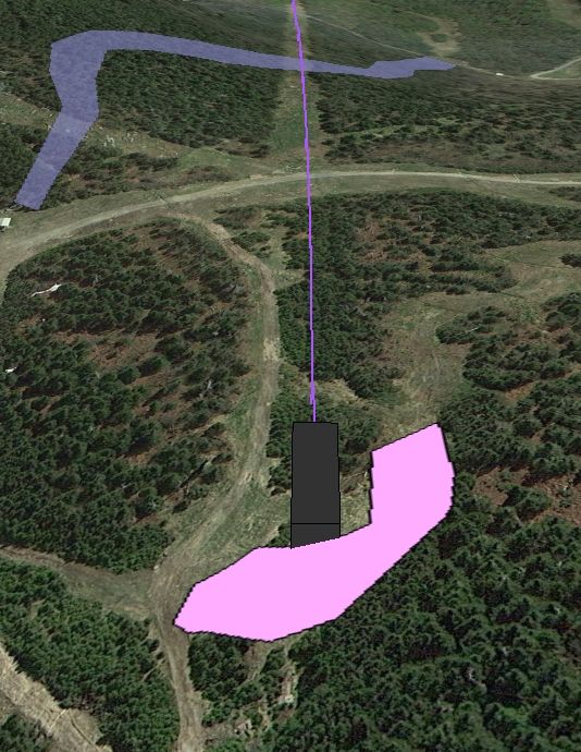
The center of the new line is actually about 14 ft south of the old double line. At the summit the old line has become rather grown in. So they will likely brush it out a bit.
You can see below that there is a definite vegetation transition to the right of the line between the terminal and Northway.
They already widened the power line this year... you can see how wide it is if you had recent photos compare to previous years.
That sounds like an excuse for continuing to screw up the second time around instead of fixing past mistakes and getting it right. :lol: Look at the Willoughby Quad at Burke for an ideal HSQ placement. A short and flat skate from the lodge. Cannon also has good placement. Waterville and Loon, also good placement. Sugarloaf, as good as can be had given the lift line.I don't think it will be much worse than getting to the lifts on Tramside.
When the new lodge is in and the re-grading all done, I don't think it will be as bad as it looks. I don't think it will be much worse than getting to the lifts on Tramside.
Compare Tramside:
To Stateside:
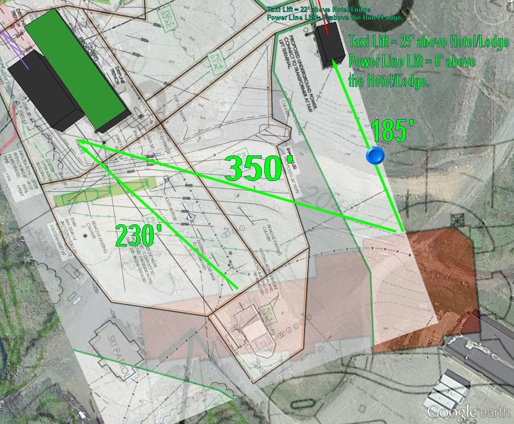
As far as I can figure from the plans, the Hotel part of the building will be primarily on the left (toward the Jet) and the lodge on the right (toward the old lodge). In the plans, you can make out a Patio/Deck area wrapping around the right side of the new Lodge. According to the contour lines on the plan, the elevation of the patio would be around 2040'. The parking lot is 20' lower that the patio. The Taxi lift is 25' higher. The Power Line lift is only 8 ft higher.
The Blue dot in the picture is a snow gun tower. I think the location of the tower plays into why the Taxi was built so far uphill.
I think those are just lines that deliniate the outter edge a buffer zone around the area that will be disturbed during the deconstruction of the Bonnie and the construction of the Power Line.
Raise Em' Jay!!! Youngin's are perfectly capable of walking.So in order to get to the lifts in what will become the key learning area for Jay, beginner skiers will need to trudge uphill between 35-45' from the parking lot? Another brilliant job by Bill Stenger!!
What's that blue area? A new trail?
But they sure as hell won't like it. Isn't the idea to make it as convenient as possible so you can hook them and raise 'em Jay? Or will they be too busy in the water park to notice?Raise Em' Jay!!! Youngin's are perfectly capable of walking.
Would that really be an intermediate run though? If so, that's a major development. I sense that would be an intermediate run just like JFK is - pretty advanced for most.Yes, you can see it in the picture above. It has been on the Masterplan for a while now. It comes right of the ridge and meanders down to feed into Lower Milk run. I figure they want to have another intermediate trail off the new 6pack rather than having everyone end up on Northway.
Would that really be an intermediate run though? If so, that's a major development. I sense that would be an intermediate run just like JFK is - pretty advanced for most.
