• Welcome to AlpineZone, the largest online community of skiers and snowboarders in the Northeast!

    You may have to REGISTER before you can post. Registering is FREE, gets rid of the majority of advertisements, and lets you participate in giveaways and other AlpineZone events!

The unofficial somewhat hopeful Friday 2/1 ?storm? thread

Euler

Active member
Joined
Jan 28, 2007
Messages
1,063
Points
36
Location
Southern Vermont
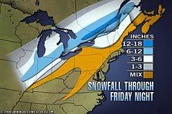
Is anyone hopeful for some goodness to come of the storm headed our way Friday? The ALY weather station has issued a winter storm warning.

SNOW WILL DEVELOP ACROSS THE WATCH AREA AROUND...OR JUST AFTER
DAYBREAK FRIDAY...WITH UP TO SEVERAL INCHES OF ACCUMULATION
POSSIBLE. THE SNOW WILL THEN MIX WITH...AND CHANGE TO SLEET AND
FREEZING RAIN BY EARLY FRIDAY AFTERNOON. THE SLEET AND FREEZING
RAIN WILL THEN CONTINUE INTO LATE FRIDAY AFTERNOON...BEFORE
CHANGING TO RAIN ACROSS LOWER ELEVATIONS. SIGNIFICANT ACCUMULATIONS
OF ICE ARE POSSIBLE ACROSS THE WATCH AREA BY LATE FRIDAY
AFTERNOON...WHICH COULD RESULT IN POWER OUTAGES AND DOWNED TREE
LIMBS. THE GREATEST PROBABILITY FOR THIS TO OCCUR WILL BE ACROSS
HIGHER ELEVATIONS...PARTICULARLY ABOVE 1200 FEET.

I'm hoping that it will do more good than harm, and that maybe, just maybe... it will be more snow than expected at high elevations and Mt. Snow will get something good.
 

mlctvt

Active member
Joined
Mar 24, 2006
Messages
1,533
Points
38
Location
CT
I've heard very little about this storm so far. Why? Maybe they aren't sure what's going to happen? I'm heading up to Mount Snow Friday night for 3-days too, let's hope we get some good accumulation befor the change over.
 

skimore

New member
Joined
Mar 15, 2005
Messages
217
Points
0
I've heard very little about this storm so far. Why? Maybe they aren't sure what's going to happen? I'm heading up to Mount Snow Friday night for 3-days too, let's hope we get some good accumulation befor the change over.

a bunch of snow then freezing rain on top???
 

nelsapbm

Member
Joined
Jul 7, 2004
Messages
540
Points
18
Location
Addison County
All of Vermont is under a winter storm watch. Supposed to start as snow and then turn to sleet/freezing rain. For those driving up here tomorrow night, be careful!
From the Burlington National Weather Service Office:
THE POTENTIAL EXISTS FOR 6 OR MORE INCHES OF SNOW AND SLEET ACROSS
THE ST. LAWRENCE VALLEY AND NORTHERN ADIRONDACKS BY EARLY SATURDAY
MORNING. ACROSS THE CHAMPLAIN VALLEY AND CENTRAL AND NORTHERN
VERMONT...SEVERAL INCHES OF SNOW PLUS SIGNIFICANT SLEET AND
FREEZING RAIN ACCUMULATIONS ARE POSSIBLE.

For the Mt. Snow area:
THE SLEET AND FREEZING RAIN ARE
EXPECTED TO CHANGE OVER TO PLAIN RAIN ACROSS LOWER ELEVATIONS...BELOW
1500 FEET...BY MID TO LATE AFTERNOON WITH FREEZING RAIN AND SLEET
OCCURRING AT THE HIGHER ELEVATIONS. SIGNIFICANT ICE ACCUMULATION
OF AROUND A HALF INCH ARE POSSIBLE...ESPECIALLY ACROSS THE HIGHER
ELEVATIONS...
 

nelsapbm

Member
Joined
Jul 7, 2004
Messages
540
Points
18
Location
Addison County
LOL Greg. It did snow in VT yesterday as the cold front blew through, so it's entirely possible that K got some snow.
 

danny p

New member
Joined
Mar 6, 2007
Messages
726
Points
0
was watching the snowfall on the k1 cam yesterday afternoon, big fat flakes at an incredibly fast rate, looked like near whiteout conditions.
 

ajl50

New member
Joined
Dec 13, 2005
Messages
702
Points
0
Location
philly
This storm is staying off people's radar because there is alot of warm air coming north..however the models keep wanting to pull the low more south and east then it was originally forcasted to go....personally I'd expect like 4 inches of snow with some sleet in the adirondacks with LOTS of sleet south and east of that.
 

billski

Active member
Joined
Feb 22, 2005
Messages
16,207
Points
38
Location
North Reading, Mass.
Website
ski.iabsi.com
Canceled my Friday plans. I am hoping to salvage something somewhere for Sunday. Maybe I'll go jet-skiing. ;)

You know, when that dump finally comes I'll be out of here so fast there will be no time to leave a message at the office. Maybe we can give someone a call list.....
 

nelsapbm

Member
Joined
Jul 7, 2004
Messages
540
Points
18
Location
Addison County
It's coming...under a warning now.

THE NATIONAL WEATHER SERVICE IN BURLINGTON HAS ISSUED A WINTER
STORM WARNING...WHICH IS IN EFFECT FROM 12 PM FRIDAY TO 5 AM EST
SATURDAY FOR THE CHAMPLAIN VALLEY OF VERMONT AND NEW YORK AS WELL
AS THE WESTERN SLOPES OF THE GREEN MOUNTAINS DUE TO SIGNIFICANT
SNOW AND ICE ACCUMULATION EXPECTED
SNOW IS EXPECTED TO OVERSPREAD THE REGION BY EARLY FRIDAY
AFTERNOON. SNOW WILL LIKELY CHANGE TO SLEET AND POSSIBLY FREEZING
RAIN BY FRIDAY EVENING AND CONTINUE FRIDAY NIGHT...POSSIBLY
BRIEFLY CHANGING TO RAIN BEFORE ENDING AS SNOW OR SNOW SHOWERS BY
DAYBREAK SATURDAY.

TOTAL SNOWFALL ACCUMULATIONS OF 3 TO 7 INCHES ALONG WITH ICE
ACCUMULATION UP TO AN HALF INCH IS POSSIBLE WITH THIS EVENT. THE
GREATER SNOW AND ICE ACCUMULATION IS LIKELY ACROSS THE NORTHERN
AREAS
 

KingM

New member
Joined
Dec 30, 2004
Messages
977
Points
0
Location
Warren, VT (Sugarbush, MRG)
Website
www.goldenlionriversideinn.com
They're preemptively calling a half day for the Warren Elementary School tomorrow. I have a feeling this is going to be an interesting one. Whatever happens, it should be a net gain.

The Accuweather (cough) 15 day forecast for the MRV is showing perfect temps and bouts of snow, yet I've been hearing about this coming warm stretch everywhere. I hope they're wrong. One good storm and correct temps and we'll be back where we were a few weeks ago.
 

danny p

New member
Joined
Mar 6, 2007
Messages
726
Points
0
from accuweather.com:

snowmap020108.jpg
 

billski

Active member
Joined
Feb 22, 2005
Messages
16,207
Points
38
Location
North Reading, Mass.
Website
ski.iabsi.com
optimistic

The gas tank is full, munchies and boots stowed in the trunk. I have burned mass quantities of sacrifice to Ullr. I'm hoping to size things up on Saturday.

Destiny calls.

Awaiting the scramble order.


p. s., I am optimistic. I will never admit to being delusional.
 
Top