• Welcome to AlpineZone, the largest online community of skiers and snowboarders in the Northeast!

    You may have to REGISTER before you can post. Registering is FREE, gets rid of the majority of advertisements, and lets you participate in giveaways and other AlpineZone events!

Week of February 2nd, storm speculation

skiberg

Member
Joined
Sep 28, 2010
Messages
588
Points
18
Can we ever just get some good news. I think the NEK is in a historic snowstorm drought,. I would be interested to know if there has ever been as prolonged period of such few major storms, as has happened for the past three years in the north country.
 

BenedictGomez

Well-known member
Joined
Jan 26, 2011
Messages
12,549
Points
113
Location
Wasatch Back
Because, judging by this map, the NWS is using MS Paint to make their forecasts now and it's easier to draw straight lines.

I'm come to the conclusion that NWS is really horrible for many weather-related things. A little more effort please, ya know.

Matt Noyes just posted a pic of the Euro 240 hr snowfall accumulation and it has all New England in the 24" range. Yes please!

Unless he added some serious caveats, that's extremely misleading/irresponsible.

That energy isnt even close to making landfall on the west coast yet. It's promising that all the models are showing some sort of large disturbance around Febuary 9th, but to post blizzard maps is a bit much.

IMO, what's happening in the digital age is that people fear that if they dont just "go" with something, they're left behind in terms of marketing themselves. People have been posting maps showing 20" and 30" inches for the northeast for Feb 9, and it gets people who dont know any better (i.e. most people) all "canned goods and bottled h2o" crazy excited, but the fact is there's much that could wrong in the next 10 days to torpedo that storm or make the 35" totals more like 3.5".
 

MadMadWorld

Active member
Joined
Jan 10, 2012
Messages
4,082
Points
38
Location
Leominster, MA
I'm come to the conclusion that NWS is really horrible for many weather-related things. A little more effort please, ya know.


Unless he added some serious caveats, that's extremely misleading/irresponsible.

That energy isnt even close to making landfall on the west coast yet. It's promising that all the models are showing some sort of large disturbance around Febuary 9th, but to post blizzard maps is a bit much.

IMO, what's happening in the digital age is that people fear that if they dont just "go" with something, they're left behind in terms of marketing themselves. People have been posting maps showing 20" and 30" inches for the northeast for Feb 9, and it gets people who dont know any better (i.e. most people) all "canned goods and bottled h2o" crazy excited, but the fact is there's much that could wrong in the next 10 days to torpedo that storm or make the 35" totals more like 3.5".

Maybe he does side work for Costco and BJ's
 

billski

Active member
Joined
Feb 22, 2005
Messages
16,207
Points
38
Location
North Reading, Mass.
Website
ski.iabsi.com
Can we ever just get some good news.

752505931_1267283.gif
 

St. Bear

New member
Joined
Dec 22, 2008
Messages
2,946
Points
0
Location
Washington, NJ
Website
twitter.com
Unless he added some serious caveats, that's extremely misleading/irresponsible.

That energy isnt even close to making landfall on the west coast yet. It's promising that all the models are showing some sort of large disturbance around Febuary 9th, but to post blizzard maps is a bit much.

IMO, what's happening in the digital age is that people fear that if they dont just "go" with something, they're left behind in terms of marketing themselves. People have been posting maps showing 20" and 30" inches for the northeast for Feb 9, and it gets people who dont know any better (i.e. most people) all "canned goods and bottled h2o" crazy excited, but the fact is there's much that could wrong in the next 10 days to torpedo that storm or make the 35" totals more like 3.5".


Of all the mets that I generally follow, he's one of the more conservative, so I'm sure he put up disclaimers galore.
 

dlague

Active member
Joined
Nov 7, 2012
Messages
8,792
Points
36
Location
CS, Colorado
Second half of winter is calling for more significant snow events and cold temps to stick around!


Sent from my iPhone using AlpineZone
 

podunk77

Member
Joined
Feb 17, 2012
Messages
122
Points
18
The video version of Matt's current NECN forecast includes a lot of caveats... he's basically talking about a pattern change over the next 10 days that brings with it more moisture than we've had for a while, and so if the temps stay cold enough we're more likely to get snow than we've been for a while.
 

from_the_NEK

Active member
Joined
Jun 5, 2006
Messages
4,576
Points
38
Location
Lyndonville, VT
Website
fineartamerica.com
Can we ever just get some good news. I think the NEK is in a historic snowstorm drought,. I would be interested to know if there has ever been as prolonged period of such few major storms, as has happened for the past three years in the north country.

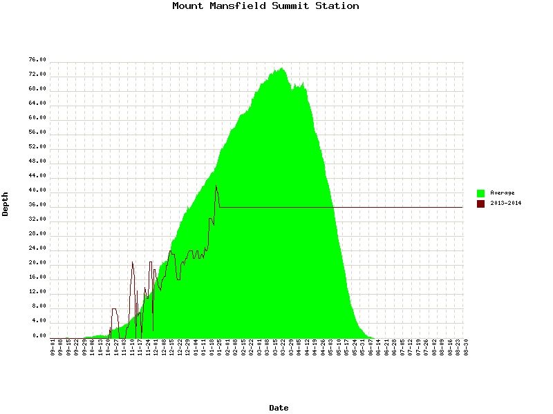
The thing is over the last three years it has JUST been the central NEK (and the NW part of NH) in this weird snow hole. To be fair to mother nature, St Johnsbury did have a few near record snow fall years in the late '00s. Now I think we may be seeing the averaging out of those years. But this snow drought is getting a bit ridiculous :)
 

catsup948

New member
Joined
Dec 6, 2007
Messages
1,026
Points
0
Location
Shelburne Falls, MA
I'm just hoping sugarloaf gets in the game a little more for the 2/5 system. I think they will do ok this weekend maybe a few inches of paste. If they can manage 10 inches by the summit I would be happy.

Sent from my SCH-I545 using Tapatalk
 

skiberg

Member
Joined
Sep 28, 2010
Messages
588
Points
18
I think there have been only like 1 or 2 storms of more than 6 inches of snow in like the past 1000 days in the NEK. That as to be some sort of historical record.
 

from_the_NEK

Active member
Joined
Jun 5, 2006
Messages
4,576
Points
38
Location
Lyndonville, VT
Website
fineartamerica.com
Let's see 1000 days would go back to...
January 31, 2014 to Jan 30, 2013 = 365 days... then to January 28, 2012 (leap year) = 730 days Back to the beginning of November 2011 = 820 days. 1000 days goes back into late winter of the 2010-11 season so I might avoid that.

My question to the Fairbanks guys would be: "Since the beginning of November 2011 (roughly 820 days ago) how many snowfall events over 6" has the Fairbanks Museum recorded?" My estimate would be 6 with only 2 over 1 ft.
 

wa-loaf

Well-known member
Joined
Jan 7, 2007
Messages
15,109
Points
48
Location
Mordor
I'm just hoping sugarloaf gets in the game a little more for the 2/5 system. I think they will do ok this weekend maybe a few inches of paste. If they can manage 10 inches by the summit I would be happy.

Sent from my SCH-I545 using Tapatalk

A nice coating for the rocks and stumps in the woods this weekend and then a big dump next week would be ideal. Going to have to go burn something ski related to appease the snow gods ...
 

from_the_NEK

Active member
Joined
Jun 5, 2006
Messages
4,576
Points
38
Location
Lyndonville, VT
Website
fineartamerica.com
Not to rub salt in the wounds, but in west/central NJ I live at the bottom of a valley at only 200' and I have nearly twice that.

At this point, I think I've become desensitized to that kind of information. How many 20"+ snowfalls have there been between NJ and S NE over the last three winters? Whatever number you come up with it is still more than here.
 
Top