• Welcome to AlpineZone, the largest online community of skiers and snowboarders in the Northeast!

    You may have to REGISTER before you can post. Registering is FREE, gets rid of the majority of advertisements, and lets you participate in giveaways and other AlpineZone events!

Week of February 2nd, storm speculation

BenedictGomez

Well-known member
Joined
Jan 26, 2011
Messages
12,546
Points
113
Location
Wasatch Back
Another busted storm for the NEK :-?. However, the 4" dense inches last night was good. All the way up the 6.5 inches at the stake.

Sweet. You'll be happy to know you're now ahead of NJ.

We lost a lot of snow yesterday with the 44 temps, I dont think we have more than 2" now. Though 3" to 6" is on the way tomorrow, we may retake the lead!
 

Wavewheeler

New member
Joined
Feb 25, 2012
Messages
495
Points
0
Location
The Jersey Shore
I hope it's in NNJ. We don't need any snow here at the coast. You can have it! But we are supposed to get 3-6". I told my friends that they were wasting their time washing their cars these past 2 days but they don't listen. I got my snow shovel out in any case.

Here it's supposed to rain Wed but up north the forecast is for SNOW. :thumbup: Let's hope that holds.
 
Joined
Sep 15, 2012
Messages
780
Points
16
Location
Boston
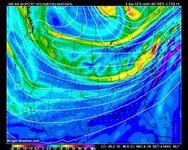
Wow, look at the big fat deformation band the GFS sticks over VT. Just wow.

post-33-0-71705800-1391380439.jpg

Congrats Stowe, MRG et.al

That band is going to linger for a while, in fact N.VT may be the last place in New England to shut off precip if that band forms as modeled.
 

BenedictGomez

Well-known member
Joined
Jan 26, 2011
Messages
12,546
Points
113
Location
Wasatch Back
They pulled it down, saying they want to focus on "one storm at a time". :)

I can 100% understand that Given recent events.

Because 99% of people don't understand how unreliable these models are outside of 4 or 5 days. The amount of 8 and 10 day "map hysteria" is really getting ridiculous.
 

fbrissette

Well-known member
Joined
Mar 19, 2012
Messages
1,672
Points
48
Location
Montreal/Jay Peak
I can 100% understand that Given recent events.

Because 99% of people don't understand how unreliable these models are outside of 4 or 5 days. The amount of 8 and 10 day "map hysteria" is really getting ridiculous.

In essence, numerical weather models have zero skill (no better than random) past 7 days for precipitation, and little skill at 5 days (they are statistically better than random, but not by much).
 

BenedictGomez

Well-known member
Joined
Jan 26, 2011
Messages
12,546
Points
113
Location
Wasatch Back
To give some idea of the unpredictability, regarding tomorrow, a snowfall that is going to START in just roughly SEVEN HOURS from now, two days ago I was in the 1" to 3" zone, yesterday 2" to 4", this morning some stuck with that lower figure and some went 3" to 6", and now as of the late night NAM explosion some say 4" to 8".

Moral of the story is, at a certain threshold this is as uncertain as Vegas putting odds on football games, and sometimes the Seahawks are going to win in a blowout.
 

Wavewheeler

New member
Joined
Feb 25, 2012
Messages
495
Points
0
Location
The Jersey Shore
Perfect soft snow today at Hunter.

.SHORT TERM /6 AM MONDAY MORNING THROUGH WEDNESDAY/...
-- Changed Discussion --
AS OF 945 PM EST...THE LATEST RAP13 AND 00Z/03 NAM12 CONTINUE TODEPICT A NORTHWARD TREND IN THE QPF ASSOCIATED WITH TOMORROW/S FASTMOVING IMPULSE. HAVE THEREFORE RAISED FORECAST SNOWFALL AMTS...TO1-3 INCHES ACROSS THE MID HUDSON VALLEY INTO NORTHERN LITCHFIELDCO...AND 2-4 INCHES FOR SOUTHERN LITCHFIELD CO. WILL HAVE TO WATCHTRENDS OVERNIGHT IN CASE THESE AMTS NEED TO BE ADJUSTED SLIGHTLYHIGHER AND/OR NORTHWARD. SOME LIGHT SNOW MAY REACH AS FAR NORTH ASCENTRAL/NORTHERN BERKSHIRE CO...AND PERHAPS EVEN SOUTHERNVT...WITH SOME VERY LIGHT SNOW OR FLURRIES POSSIBLY REACHING INTOSOUTHERN PORTIONS OF THE CAPITAL REGION.

AND it's supposed to snow all night on Tuesday and all day Wednesday. :thumbup:
If so, I will be going Thursday and Friday. :snow:
 

Attachments

  • 44303_520731911283104_365453506_n.jpg
    44303_520731911283104_365453506_n.jpg
    40.1 KB · Views: 76
Last edited:
Top