• Welcome to AlpineZone, the largest online community of skiers and snowboarders in the Northeast!

    You may have to REGISTER before you can post. Registering is FREE, gets rid of the majority of advertisements, and lets you participate in giveaways and other AlpineZone events!

November 1? *Drumbeats*

Joined
Sep 15, 2012
Messages
780
Points
16
Location
Boston
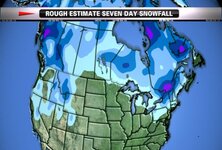
The models are all over the place, that's for sure. One thing is for certain, however, we have a very interesting pattern setting up. A Coastal Storm is on the models' radar, and this time, NNE may see some flakes.

Nothing is set in stone right now, the remnants of Hurricane Ana are messing with the models right now so funky solutions are being put out, but the "Key Ingredients" for a stream phase will be in play by the end of the month.

This is just something to speculate on. If Ana cooperates, there may be a wintry storm for the Northern Greens and Maine.:snow:
 

Tin

Active member
Joined
Oct 14, 2009
Messages
2,996
Points
38
Location
ZooMass Slamherst
Either way this is going to screw things up because despite the low temps the humidity will be too high to make snow and if they did get snow in the Greens or Maine it wouldn't be enough to open (especially looking at a few days in the 50s and rain the following week). Would rather just avoid the system and high humidity so K and SR can start blowing snow.
 
Joined
Sep 15, 2012
Messages
780
Points
16
Location
Boston
Also cheers everyone! I know I'm excited for another winter of storm watching!


ETA: Nice blocking signal
 
Last edited:

BenedictGomez

Well-known member
Joined
Jan 26, 2011
Messages
12,130
Points
113
Location
Wasatch Back
Either way this is going to screw things up because despite the low temps the humidity will be too high to make snow and if they did get snow in the Greens or Maine it wouldn't be enough to open (especially looking at a few days in the 50s and rain the following week). Would rather just avoid the system and high humidity so K and SR can start blowing snow.

Yeah, these late October and early November events dont excite me, because they all just melt anyway.
 

Nick

Administrator
Staff member
Administrator
Joined
Nov 12, 2010
Messages
13,176
Points
48
Location
Bradenton, FL
Website
www.alpinezone.com
http://www.necn.com/weather/stories/Tricky-Halloween-Forecast-280473522.html?3

attachment.php
 

Attachments

  • TIM_EAST_MOVIE_HD.jpg
    TIM_EAST_MOVIE_HD.jpg
    47.9 KB · Views: 326
Joined
Sep 15, 2012
Messages
780
Points
16
Location
Boston
Models are coming into focus, and there is indeed a storm. Some runs have brought snow into the NW metro area of Boston!
 
Joined
Sep 15, 2012
Messages
780
Points
16
Location
Boston
No lie... here is the Burlington discussion on the storm.

Given recent trends for systems to become more cutoff and closed...for prevailing westerly follow...and models showing a developing/amplifying ridge across the Central Plains...will trend toward the European model (ecmwf) solution. This supports chance/likely probability of precipitation late Friday night into Saturday...as 850 to 500mb moisture associated with developing trough increases from west to east across our region. Additional precipitation...mainly in the form of snow would be likely across our central/eastern section Sat night into Sunday...with a sharp precipitation/accumulation gradient expected. Very limited quantitative precipitation forecast/snow would occur along and west of the cpv if the European model (ecmwf) solution verified...with some upslope enhancement for the western slopes possible. Prognosticated 850 mb temperatures drop between -8 and -10c...while 925mb temperatures are <0c by 00z Sunday with soundings showing the freezing level between 200 and 400 feet...supporting snow in the valleys away from Lake Champlain. Given warm ground temperatures and marginal bl profiles...not expecting much accumulation in the slv/cpv. Temperatures will struggle in the 30s Sat/Sunday in the valleys with brisk north winds. If you have plans in the mountains this weekend...plan for middle winter conditions...with temperatures only in the teens and 20s with gusty northwest winds...and accumulating snow...especially Sat into Sunday. Too early for accumulations but I would have the rock skis on standby this weekend...if you are looking for the 1st turns of the season along The Spine of the Green Mountains from Jay Peak to Mansfield to Killington.
 

mriceyman

New member
Joined
Jan 4, 2012
Messages
1,344
Points
0
Location
cnj
Honestly the whole warm ground thing i believe is a big myth. Last year in jersey( maybe 2 years ago) we had no prolonged cold and an 78* day before a 6+" snowfall accumulating on grass and pavement. If it gets cold enough (below 30 or so) and is snowing hard enough it will stick.


Sent from my iPhone using AlpineZone
 

St. Bear

New member
Joined
Dec 22, 2008
Messages
2,946
Points
0
Location
Washington, NJ
Website
twitter.com
Honestly the whole warm ground thing i believe is a big myth. Last year in jersey( maybe 2 years ago) we had no prolonged cold and an 78* day before a 6+" snowfall accumulating on grass and pavement. If it gets cold enough (below 30 or so) and is snowing hard enough it will stick.


Sent from my iPhone using AlpineZone

It'll stick, sure, but a cold ground would mean that 6+" could've easily been 10+".
 
Top