ChicoKat
New member
All is not lost, maybe the Jay Cloud and the Cannon Effect are joining forces over wildcat. http://www.snowforecast.com/resorts/4654-wildcat-mountain-ski-resort

Welcome to AlpineZone, the largest online community of skiers and snowboarders in the Northeast!
You may have to REGISTER before you can post. Registering is FREE, gets rid of the majority of advertisements, and lets you participate in giveaways and other AlpineZone events!
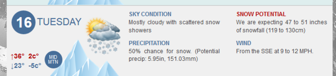
Scattered snow showers totaling four feet of snow! Ski at last, we can ski at last!
:blink:
")
I'm still not convinced that we're gonna die.
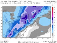
1. These storms always trend towards the coast.
2. Considering how each model was showing something totally different yesterday, I'm not convinced this is our final track
3. Not buying a 60 degree temperature swing from Sunday morning to Tuesday night.
Scattered snow showers totaling four feet of snow! Ski at last, we can ski at last!
*Disclaimer* - Common Core math might of been used to arrive at those estimate totals
#1 has more than been the case this year. Overwhelmingly this year as the model runs progress and the actual storm time approaches, there's been a distinct shift East. If this storm does that by 50 to 100 miles, then ski country does pretty well
#1 has more than been the case this year. Overwhelmingly this year as the model runs progress and the actual storm time approaches, there's been a distinct shift East. If this storm does that by 50 to 100 miles, then ski country does pretty well
All is not lost, maybe the Jay Cloud and the Cannon Effect are joining forces over wildcat.

One bit of good news (though I'm sort of reaching), the ECMWF ensembles are out, and they're as far west as roughly Niagara Falls, and as far east as the benchmark (i.e. it seems the model is incredibly confused). And given how dramatically west the GFS and Canuck have moved, it seems like they're all confused. Just pray for the best.
anyone want to trade some xanax for my remaining lift tix?

18Z GFS comes even more west.
I wont post a picture, lest there be children watching.
Maybe it'll keep going west and rain in Detroit and we'll have a nice, sunny, spring skiing week?
#DailyDelusion