• Welcome to AlpineZone, the largest online community of skiers and snowboarders in the Northeast!

    You may have to REGISTER before you can post. Registering is FREE, gets rid of the majority of advertisements, and lets you participate in giveaways and other AlpineZone events!

Winter Forecast 2015-2016

ss20

Well-known member
Joined
Jan 13, 2013
Messages
3,990
Points
113
Location
A minute from the Alta exit off the I-15!
I'm still not convinced that we're gonna die.

1. These storms always trend towards the coast.
2. Considering how each model was showing something totally different yesterday, I'm not convinced this is our final track
3. Not buying a 60 degree temperature swing from Sunday morning to Tuesday night.
 

drjeff

Well-known member
Joined
Jan 18, 2006
Messages
19,413
Points
113
Location
Brooklyn, CT
I'm still not convinced that we're gonna die.

1. These storms always trend towards the coast.
2. Considering how each model was showing something totally different yesterday, I'm not convinced this is our final track
3. Not buying a 60 degree temperature swing from Sunday morning to Tuesday night.

#1 has more than been the case this year. Overwhelmingly this year as the model runs progress and the actual storm time approaches, there's been a distinct shift East. If this storm does that by 50 to 100 miles, then ski country does pretty well
 

ss20

Well-known member
Joined
Jan 13, 2013
Messages
3,990
Points
113
Location
A minute from the Alta exit off the I-15!
#1 has more than been the case this year. Overwhelmingly this year as the model runs progress and the actual storm time approaches, there's been a distinct shift East. If this storm does that by 50 to 100 miles, then ski country does pretty well

Yep. How many storms have we lost by going "out-to-sea"? How many storms have we lost "in-too-inland"?
 

BenedictGomez

Well-known member
Joined
Jan 26, 2011
Messages
12,583
Points
113
Location
Wasatch Back
#1 has more than been the case this year. Overwhelmingly this year as the model runs progress and the actual storm time approaches, there's been a distinct shift East. If this storm does that by 50 to 100 miles, then ski country does pretty well

I mentioned this yesterday, but that has not been the case at all, with the exception of the last 2 bits of energy that went OTS. Almost every storm this year has "real world" moved to the west of guidance.

It's a different thing altogether to say "at the last minute" it went east of the final guidance, but in the long and intermediate range they've moved west. This one is too. The GFS and Canadian are WAY west of the previous run, and the Euro just went bizarrely west (to the point I wonder if something is wrong with it).

The best and most positive thing I can think to say, is that thank god it's 5 days away, but if the general idea here becomes reality, it's pretty catastrophic. Nasty ice storm, torrential rains, sleet, high winds, and some snow. I'm hoping for the best (obviously), but I'm pretty worried.
 

BenedictGomez

Well-known member
Joined
Jan 26, 2011
Messages
12,583
Points
113
Location
Wasatch Back
One bit of good news (though I'm sort of reaching), the ECMWF ensembles are out, and they're as far west as roughly Niagara Falls, and as far east as the benchmark (i.e. it seems the model is incredibly confused). And given how dramatically west the GFS and Canuck have moved, it seems like they're all confused. Just pray for the best.
 

BenedictGomez

Well-known member
Joined
Jan 26, 2011
Messages
12,583
Points
113
Location
Wasatch Back
Just listened to Bernie Rayno's early read on this. Looking at his chart, he thinks it will come in maybe 40'ish miles south and east of modeled.

That would spare ADK and VT, but be bad for Poconos, Cats (though maybe Platty gets spared) and just pretty horrible for Berks. It's not great for a lot of ski areas, but given how terrible this could be, I'd take his track and lock it in right now if I could.

image.gif
 

catsup948

New member
Joined
Dec 6, 2007
Messages
1,026
Points
0
Location
Shelburne Falls, MA
One bit of good news (though I'm sort of reaching), the ECMWF ensembles are out, and they're as far west as roughly Niagara Falls, and as far east as the benchmark (i.e. it seems the model is incredibly confused). And given how dramatically west the GFS and Canuck have moved, it seems like they're all confused. Just pray for the best.

GFS ensembles
 

Attachments

  • 1455228090927.jpg
    1455228090927.jpg
    111.9 KB · Views: 116

ss20

Well-known member
Joined
Jan 13, 2013
Messages
3,990
Points
113
Location
A minute from the Alta exit off the I-15!
Maybe it'll keep going west and rain in Detroit and we'll have a nice, sunny, spring skiing week?

#DailyDelusion
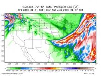
Well, most of the rain is going to the west of the NYS Thruway... 3 inches of rain over there while the rest of ski country "escapes" with 1-2 inches of rain.

USA_APCPI72_sfc_144.jpg

I'm holding out until tomorrow until I call this a washout. Still hopeful.


Anyone wanna make a thread for this storm? Not too wintery but there's been enough discussion about it to warrant it's own spot.
 
Top