• Welcome to AlpineZone, the largest online community of skiers and snowboarders in the Northeast!

    You may have to REGISTER before you can post. Registering is FREE, gets rid of the majority of advertisements, and lets you participate in giveaways and other AlpineZone events!

"... home to Southern Vermont's most advanced terrain"

VTKilarney

Well-known member
Joined
Feb 5, 2014
Messages
5,553
Points
63
Location
VT NEK
Another geographical oddity: on the Poultney River, north of Whitehall, you can stand in NY and look off towards the West and be looking at Vermont.
I've always wished that there was a road that crossed that part of Vermont. It would be cool to say that you drove through Vermont in just a few minutes.
 

ScottySkis

Well-known member
Joined
Jan 16, 2011
Messages
12,294
Points
48
Location
Middletown NY
East Wallingford is just off 103 between Ludlow and Rutland, on the Mill River. Wallingford proper is on 7, where Roaring Brook enters Otter Creek.

Another geographical oddity: on the Poultney River, north of Whitehall, you can stand in NY and look off towards the West and be looking at Vermont.

How that possible?
 

Mapnut

New member
Joined
Sep 21, 2006
Messages
644
Points
0
Location
Connecticut
Wait, you have to drive through Canada to get to Point Roberts, WA? Anyone know how that happened?
(Notice that I am not apologizing for hijacking the thread.)
 

VTKilarney

Well-known member
Joined
Feb 5, 2014
Messages
5,553
Points
63
Location
VT NEK
See also: Province Point in Lake Champlain and Province Island in Lake Memphramagog (actually there is no road access to that one, boat only).
There isn't road access to either one. That is what Point Roberts so unique.
 

Puck it

Well-known member
Joined
Oct 26, 2006
Messages
9,700
Points
48
Location
Franconia, NH
And don't forget about the section of Minnesota that is completely surrounded by Canada. Landlocked by the Canucks.
 

ironhippy

Member
Joined
May 16, 2014
Messages
410
Points
18
Location
NB Canda
we had numerous farms near by that could only access their land by travelling on a road on the other side of the border

9/11 put an end to that
 

mister moose

Well-known member
Joined
Oct 11, 2007
Messages
1,097
Points
48
Since this thread has morphed into geographical oddities... and since the snow is so bleak at the moment...

Let me tell you the story of Seal Island, somewhere off the coast of far northeastern Maine. I'm not taking the time to google proofread this, so some facts may be dusty. And not much is on the internet. Seal Island doesn't even show on most maps. Trust me, it's there.

I do a lot of long distance sailing at times, and on one trip we happened along Seal Island out in the gulf of Maine, pretty far up. Fog bound, rocky coast, 20 foot tides far up. It turns out there is some very rich history right before your eyes in that area. At least according to the descendants still living in the area.

Back in the war of 1812, Barna Beale apparently led a force to successfully repel the British forces in the area, and among the spoils was Seal Island off the coast. This is in an area where Canada and the US blend, as Maine goes Northeast yet Grand Manan off the coast is Canada. To this day, a descendant of Barna Beale travels each day to Seal Island, staking his ancestral claim to the land. He has a 45 foot or so charter boat that carries about a 10 foot US flag off the stern. which is a way bigger flag than average, in case you haven't been on 45 foot charter boats lately.

There is a reason.

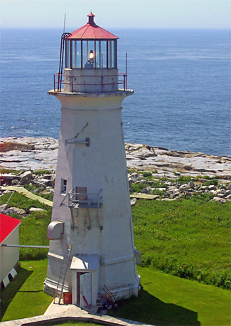
Back to the foggy, rocky current laden coast. At the head of the Gulf of Maine, lies the city of St John, New Brunswick. (Don't ever say St John's, that is a Newfie town, and they are very sensitive about that) Canadian shipping up and down the Bay of Fundy to St John had lots of trouble encountering rocks and ledges, so they built lighthouses prolifically along their coastline. All of which are painted red and white, all of which have a unique paint scheme. Someone sat in a room years ago and came up with this, so upon sighting a Canadian lighthouse you know exactly which one it was. So in the 1840's, (Turns out it's 1834) I forget the exact year, Canada asked the US to build a lighthouse on Seal Island. The US said sure, no skin off our nose. It's just a rock. As in many disputes, The US didn't get the agreement in writing. Seal Island is a few square miles of grass covered rock. The lighthouse was built by Canada, and every day since then a Canadian lighthouse keeper has stood the watch, cleaned the lens, filled the oil lamp, trimmed the wick. Even today, with automated lights, the Seal Island lighthouse keeper continues to stand his watch. All this to keep Canadian ships off the rock ledges in the area. None of this mattered to anyone until recently.

What caught everyone's attention, well it caught the fishermen's attention, is when the 12 mile territorial waters act went in. Suddenly a 12 mile circle around Seal Island was important, as it determined who could fish there in some very fruitful waters. The Canadians said it is our island, we have occupied it since 1834. The US said it is our Island, we got it in 1812. And so it began.

While we were on the Island, I met and talked with the current lighthouse keeper. I asked him about the dispute. "There is no dispute", he said matter of factly. "It is our Island".

I also met and talked with the descendant of Barna Beale (Not hard, it is a really small island), whose great great grandfather fought off the British. He insists the Island is the US, and every day he plants the flag in the soil under the eye of the lighthouse keeper. He live on nearby (get ready) Beale Island. Just off Jonesport where they race lobster boats with big engines at over 80 mph. If you've ever seen a lobster boat you'll know this is impressive.

The land is still in dispute. It has gone to the Hague. Little Seal Island, in the Hague.

After we left the island, we next went to Eastport, a port of entry in Maine. There is a huge sign as you come up the ramp from the float (We're now at 35 foot tides). It says "All Vessels entering from foreign ports must check in upon arrival under penalty of forfeiture of the captain", or something. We look at each other, and wonder, did we just come in from Canada? Or the US? So we walk across the street to the ancient, stone customs house. Do we need to report, I asked. "Where did you come from", he queried. Seal Island.

"Get out. I don't want to talk about it. Get out."

At first I thought he was joking, but then I could see he was serious. Later it occurred to me that if he cleared us in, he would take authority in an international dispute. So out we went.

Seal Island is the last disputed territory between Canada and the US, and the last I knew, is still in dispute to this day. The fact that most maps don't show it makes it even more mysterious and legendary.

The other interesting thing about Seal Island is that it is one of the very few Rookeries for the Atlantic Puffin in the US. The only others are Easter Egg Is, Matinicus Rock, and maybe one other. The Puffin is a bird, but looks like a relative of a duck, and behaves like a cross of a goose and a chimpanzee. They are lots of fun to watch. The best is watching them land. They can't fly to a stop, they are more like transport category birds that need fast approach speeds. It's sometimes like a controlled collision; they glide in with feet extended, stretching forward reaching for the ground, right to the edge of a stall... and frequently they do stall and tumble, or they do a fast running landing whoop whoop, whew! They must be heavy for their size, and their wings are small. The blade beat is extremely fast. Their call sounds like little chain saws whirring. That day I burned 3 rolls of film on just Puffins. Because their mating season is strictly protected, access to the island is limited. We were extremely lucky to wander into the ability to go ashore.

machiassealisland2_re.jpg


The lighthouse

7b2f342017aedbf15ce3c1d2e49a66ee.jpg

The colorful Atlantic Puffin.


A long story, but we're not skiing, so why not.

**Edit:
Found this depicting the area, the disputed territorial waters, and the "Grey Zone" of contention.

CUS915.gif
 
Last edited:

j law

New member
Joined
Jan 19, 2011
Messages
103
Points
0
Location
NYC
"... home to Southern Vermont's most advanced terrain"

Magic rocks and the marketing is sound. It's Jay Peak south in my book. My new fav place to hit when the snow is right and I can't get north of Wallingford!


Sent from my iPhone
 

Highway Star

Active member
Joined
Sep 27, 2005
Messages
2,921
Points
36
Since this thread has morphed into geographical oddities... and since the snow is so bleak at the moment...

Let me tell you the story of Seal Island, somewhere off the coast of far northeastern Maine. I'm not taking the time to google proofread this, so some facts may be dusty. And not much is on the internet. Seal Island doesn't even show on most maps. Trust me, it's there.

I do a lot of long distance sailing at times, and on one trip we happened along Seal Island out in the gulf of Maine, pretty far up. Fog bound, rocky coast, 20 foot tides far up. It turns out there is some very rich history right before your eyes in that area. At least according to the descendants still living in the area.

Back in the war of 1812, Barna Beale apparently led a force to successfully repel the British forces in the area, and among the spoils was Seal Island off the coast. This is in an area where Canada and the US blend, as Maine goes Northeast yet Grand Manan off the coast is Canada. To this day, a descendant of Barna Beale travels each day to Seal Island, staking his ancestral claim to the land. He has a 45 foot or so charter boat that carries about a 10 foot US flag off the stern. which is a way bigger flag than average, in case you haven't been on 45 foot charter boats lately.

There is a reason.

Back to the foggy, rocky current laden coast. At the head of the Gulf of Maine, lies the city of St John, New Brunswick. (Don't ever say St John's, that is a Newfie town, and they are very sensitive about that) Canadian shipping up and down the Bay of Fundy to St John had lots of trouble encountering rocks and ledges, so they built lighthouses prolifically along their coastline. All of which are painted red and white, all of which have a unique paint scheme. Someone sat in a room years ago and came up with this, so upon sighting a Canadian lighthouse you know exactly which one it was. So in the 1840's, (Turns out it's 1834) I forget the exact year, Canada asked the US to build a lighthouse on Seal Island. The US said sure, no skin off our nose. It's just a rock. As in many disputes, The US didn't get the agreement in writing. Seal Island is a few square miles of grass covered rock. The lighthouse was built by Canada, and every day since then a Canadian lighthouse keeper has stood the watch, cleaned the lens, filled the oil lamp, trimmed the wick. Even today, with automated lights, the Seal Island lighthouse keeper continues to stand his watch. All this to keep Canadian ships off the rock ledges in the area. None of this mattered to anyone until recently.

What caught everyone's attention, well it caught the fishermen's attention, is when the 12 mile territorial waters act went in. Suddenly a 12 mile circle around Seal Island was important, as it determined who could fish there in some very fruitful waters. The Canadians said it is our island, we have occupied it since 1834. The US said it is our Island, we got it in 1812. And so it began.

While we were on the Island, I met and talked with the current lighthouse keeper. I asked him about the dispute. "There is no dispute", he said matter of factly. "It is our Island".

I also met and talked with the descendant of Barna Beale (Not hard, it is a really small island), whose great great grandfather fought off the British. He insists the Island is the US, and every day he plants the flag in the soil under the eye of the lighthouse keeper. He live on nearby (get ready) Beale Island. Just off Jonesport where they race lobster boats with big engines at over 80 mph. If you've ever seen a lobster boat you'll know this is impressive.

The land is still in dispute. It has gone to the Hague. Little Seal Island, in the Hague.

After we left the island, we next went to Eastport, a port of entry in Maine. There is a huge sign as you come up the ramp from the float (We're now at 35 foot tides). It says "All Vessels entering from foreign ports must check in upon arrival under penalty of forfeiture of the captain", or something. We look at each other, and wonder, did we just come in from Canada? Or the US? So we walk across the street to the ancient, stone customs house. Do we need to report, I asked. "Where did you come from", he queried. Seal Island.

"Get out. I don't want to talk about it. Get out."

At first I thought he was joking, but then I could see he was serious. Later it occurred to me that if he cleared us in, he would take authority in an international dispute. So out we went.

Seal Island is the last disputed territory between Canada and the US, and the last I knew, is still in dispute to this day. The fact that most maps don't show it makes it even more mysterious and legendary.

The other interesting thing about Seal Island is that it is one of the very few Rookeries for the Atlantic Puffin in the US. The only others are Easter Egg Is, Matinicus Rock, and maybe one other. The Puffin is a bird, but looks like a relative of a duck, and behaves like a cross of a goose and a chimpanzee. They are lots of fun to watch. The best is watching them land. They can't fly to a stop, they are more like transport category birds that need fast approach speeds. It's sometimes like a controlled collision; they glide in with feet extended, stretching forward reaching for the ground, right to the edge of a stall... and frequently they do stall and tumble, or they do a fast running landing whoop whoop, whew! They must be heavy for their size, and their wings are small. The blade beat is extremely fast. Their call sounds like little chain saws whirring. That day I burned 3 rolls of film on just Puffins. Because their mating season is strictly protected, access to the island is limited. We were extremely lucky to wander into the ability to go ashore.

machiassealisland2_re.jpg


The lighthouse

7b2f342017aedbf15ce3c1d2e49a66ee.jpg

The colorful Atlantic Puffin.


A long story, but we're not skiing, so why not.

**Edit:
Found this depicting the area, the disputed territorial waters, and the "Grey Zone" of contention.

CUS915.gif

That is amazing! I found this cool nat-geo video of the island and its wildlife:

https://www.youtube.com/watch?v=dQw4w9WgXcQ
 

chuckstah

Well-known member
Joined
Mar 22, 2013
Messages
1,629
Points
83
Since this thread has morphed into geographical oddities... and since the snow is so bleak at the moment...

Let me tell you the story of Seal Island, somewhere off the coast of far northeastern Maine. I'm not taking the time to google proofread this, so some facts may be dusty. And not much is on the internet. Seal Island doesn't even show on most maps. Trust me, it's there.

I do a lot of long distance sailing at times, and on one trip we happened along Seal Island out in the gulf of Maine, pretty far up. Fog bound, rocky coast, 20 foot tides far up. It turns out there is some very rich history right before your eyes in that area. At least according to the descendants still living in the area.

Back in the war of 1812, Barna Beale apparently led a force to successfully repel the British forces in the area, and among the spoils was Seal Island off the coast. This is in an area where Canada and the US blend, as Maine goes Northeast yet Grand Manan off the coast is Canada. To this day, a descendant of Barna Beale travels each day to Seal Island, staking his ancestral claim to the land. He has a 45 foot or so charter boat that carries about a 10 foot US flag off the stern. which is a way bigger flag than average, in case you haven't been on 45 foot charter boats lately.

There is a reason.

Back to the foggy, rocky current laden coast. At the head of the Gulf of Maine, lies the city of St John, New Brunswick. (Don't ever say St John's, that is a Newfie town, and they are very sensitive about that) Canadian shipping up and down the Bay of Fundy to St John had lots of trouble encountering rocks and ledges, so they built lighthouses prolifically along their coastline. All of which are painted red and white, all of which have a unique paint scheme. Someone sat in a room years ago and came up with this, so upon sighting a Canadian lighthouse you know exactly which one it was. So in the 1840's, (Turns out it's 1834) I forget the exact year, Canada asked the US to build a lighthouse on Seal Island. The US said sure, no skin off our nose. It's just a rock. As in many disputes, The US didn't get the agreement in writing. Seal Island is a few square miles of grass covered rock. The lighthouse was built by Canada, and every day since then a Canadian lighthouse keeper has stood the watch, cleaned the lens, filled the oil lamp, trimmed the wick. Even today, with automated lights, the Seal Island lighthouse keeper continues to stand his watch. All this to keep Canadian ships off the rock ledges in the area. None of this mattered to anyone until recently.

What caught everyone's attention, well it caught the fishermen's attention, is when the 12 mile territorial waters act went in. Suddenly a 12 mile circle around Seal Island was important, as it determined who could fish there in some very fruitful waters. The Canadians said it is our island, we have occupied it since 1834. The US said it is our Island, we got it in 1812. And so it began.

While we were on the Island, I met and talked with the current lighthouse keeper. I asked him about the dispute. "There is no dispute", he said matter of factly. "It is our Island".

I also met and talked with the descendant of Barna Beale (Not hard, it is a really small island), whose great great grandfather fought off the British. He insists the Island is the US, and every day he plants the flag in the soil under the eye of the lighthouse keeper. He live on nearby (get ready) Beale Island. Just off Jonesport where they race lobster boats with big engines at over 80 mph. If you've ever seen a lobster boat you'll know this is impressive.

The land is still in dispute. It has gone to the Hague. Little Seal Island, in the Hague.

After we left the island, we next went to Eastport, a port of entry in Maine. There is a huge sign as you come up the ramp from the float (We're now at 35 foot tides). It says "All Vessels entering from foreign ports must check in upon arrival under penalty of forfeiture of the captain", or something. We look at each other, and wonder, did we just come in from Canada? Or the US? So we walk across the street to the ancient, stone customs house. Do we need to report, I asked. "Where did you come from", he queried. Seal Island.

"Get out. I don't want to talk about it. Get out."

At first I thought he was joking, but then I could see he was serious. Later it occurred to me that if he cleared us in, he would take authority in an international dispute. So out we went.

Seal Island is the last disputed territory between Canada and the US, and the last I knew, is still in dispute to this day. The fact that most maps don't show it makes it even more mysterious and legendary.

The other interesting thing about Seal Island is that it is one of the very few Rookeries for the Atlantic Puffin in the US. The only others are Easter Egg Is, Matinicus Rock, and maybe one other. The Puffin is a bird, but looks like a relative of a duck, and behaves like a cross of a goose and a chimpanzee. They are lots of fun to watch. The best is watching them land. They can't fly to a stop, they are more like transport category birds that need fast approach speeds. It's sometimes like a controlled collision; they glide in with feet extended, stretching forward reaching for the ground, right to the edge of a stall... and frequently they do stall and tumble, or they do a fast running landing whoop whoop, whew! They must be heavy for their size, and their wings are small. The blade beat is extremely fast. Their call sounds like little chain saws whirring. That day I burned 3 rolls of film on just Puffins. Because their mating season is strictly protected, access to the island is limited. We were extremely lucky to wander into the ability to go ashore.

machiassealisland2_re.jpg


The lighthouse

7b2f342017aedbf15ce3c1d2e49a66ee.jpg

The colorful Atlantic Puffin.


A long story, but we're not skiing, so why not.

**Edit:
Found this depicting the area, the disputed territorial waters, and the "Grey Zone" of contention.

CUS915.gif

And they taste good too! On lots of menus in Iceland, and even served on Icelandair. However, if they are now in decline, I would no longer recommend harvesting them for food.
 
Top