skiberg
Member
- Joined
- Sep 28, 2010
- Messages
- 588
- Points
- 18
What's a big change? I don't see this on any forecasts unless you mean a return to more seasonable temps. I think we get on snow by turkey day, but it is not going to be pretty.
Welcome to AlpineZone, the largest online community of skiers and snowboarders in the Northeast!
You may have to REGISTER before you can post. Registering is FREE, gets rid of the majority of advertisements, and lets you participate in giveaways and other AlpineZone events!
.What's a big change? I don't see this on any forecasts unless you mean a return to more seasonable temps. I think we get on snow by turkey day, but it is not going to be pretty.
This is tease maybe. If storms like these actually happen this winter Central and northern Vermont is going to get destroyed and the upslope... Wow!
That is a 10 day forecast. At those lead times there is a resolution shift in the GFS. Because of the model numerics there is a big upscale cascade of energy in the model. The result is unrealistically robust synoptic scale systems. These forecasts are useful only for ensemble products to investigate the probability of synoptic scale ridges and troughs.
Sent from my iPhone using AlpineZone mobile app
I agree with this (at least I think I do). Given that this is so long range of a forecast it really only gives a general idea of what patterns may emerge. Look at this taken from this morning's model of the same system, still almost 10 days out. Still a strong surge from the southern jet with an equal push of a mass of cold air.That is a 10 day forecast. At those lead times there is a resolution shift in the GFS. Because of the model numerics there is a big upscale cascade of energy in the model. The result is unrealistically robust synoptic scale systems. These forecasts are useful only for ensemble products to investigate the probability of synoptic scale ridges and troughs.
I agree with this (at least I think I do). Given that this is so long range of a forecast it really only gives a general idea of what patterns may emerge. Look at this taken from this morning's model of the same system, still almost 10 days out. Still a strong surge from the southern jet with an equal push of a mass of cold air.


If I knew where to find these models I'd look them up. I also don't like the look of these forecasts. Are those for the same time period?If you're looking that far out, you really should be looking at the ensemble means averaged over a time window. Averaging over a number of ensemble members helps account for the fact that the system is non-linear and chaotic. Averaging over a time window helps wash out the influence of slight phasing errors of transient disturbances.

Source page:If I knew where to find these models I'd look them up. I also don't like the look of these forecasts. Are those for the same time period?
Source page:
http://mp1.met.psu.edu/~fxg1/ewall.html
Specific image link:
http://mp1.met.psu.edu/~fxg1/CMCNA_0z/hgtcomp.html
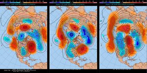
Yes, from left to right is the ECMWF, GFS, and CMC ensembles valid Thursday - Saturday of next week. As you can see, the signal is very robust. The contour lines are ensemble mean 500 mb heights, and colors are the anomaly. The pattern show is a strong ridge in the east and trough in the west.
I'm sorry to be the bearer of bad news.
Can't we just stick with "the models are always wrong" theory ?
50s until mid December.
Ban him to Mizzou and tell them he is a journalist!!!!!!!Its easy to get banned with posts like that!Lol...
50s until mid December.
50s until mid December.