• Welcome to AlpineZone, the largest online community of skiers and snowboarders in the Northeast!

    You may have to REGISTER before you can post. Registering is FREE, gets rid of the majority of advertisements, and lets you participate in giveaways and other AlpineZone events!

Winter Pattern Has Arrived - Will it Bring Snow?

BenedictGomez

Well-known member
Joined
Jan 26, 2011
Messages
12,546
Points
113
Location
Wasatch Back
This is getting better and better for me. Trend (NW) is my friend.

Even the Euro absolutely caved and is spitting out decent pcp now.

Also, IMO it doesnt seem like people are properly accounting for the artic air that should be locked in place. Seems most are conservatively using 15:1, but 17:1 or 18:1 etc... are definitely possible here. Maybe even 20:1 if we dare to dream.
 

billski

Active member
Joined
Feb 22, 2005
Messages
16,207
Points
38
Location
North Reading, Mass.
Website
ski.iabsi.com
This is getting better and better for me. Trend (NW) is my friend.

Even the Euro absolutely caved and is spitting out decent pcp now.

Also, IMO it doesnt seem like people are properly accounting for the artic air that should be locked in place. Seems most are conservatively using 15:1, but 17:1 or 18:1 etc... are definitely possible here. Maybe even 20:1 if we dare to dream.

Yeah, but that freaking wind on Wed. is going to blow it all away.
 

billski

Active member
Joined
Feb 22, 2005
Messages
16,207
Points
38
Location
North Reading, Mass.
Website
ski.iabsi.com
Anyone know where I could find a season snowfall total for the Tug Hill? They've been getting one 2 foot+ snowstorm after another...
Nobody is tracking that as best as I can tell. They may have all died once the snow hit the top of the water tower ;) Closest might be Snow Ridge, but their data is sketchy and inconsistent. http://www.onthesnow.com/new-york/snow-ridge/historical-snowfall.html?&y=2013&q=snow

Snow ridge is reporting 40" depth at the summit.

Go to western NY and you'll find Kissing Bridge with 48" depth (that won't be gone until July!) that's one place that is getting seriously hammered. http://www.onthesnow.com/new-york/kissing-bridge/historical-snowfall.html?&y=2013
 
Last edited:

Euler

Active member
Joined
Jan 28, 2007
Messages
1,063
Points
36
Location
Southern Vermont
Nobody is tracking that as best as I can tell. They may have all died once the snow hit the top of the water tower ;) Closest might be Snow Ridge, but their data is sketchy and inconsistent. http://www.onthesnow.com/new-york/snow-ridge/historical-snowfall.html?&y=2013&q=snow

Snow ridge is reporting 40" depth at the summit.

Go to western NY and you'll find Kissing Bridge with 48" depth (that won't be gone until July!) that's one place that is getting seriously hammered. http://www.onthesnow.com/new-york/kissing-bridge/historical-snowfall.html?&y=2013

I'm looking for a legit weather source, not ski area spin.
 

xwhaler

Active member
Joined
Nov 26, 2007
Messages
2,943
Points
38
Location
Seacoast NH
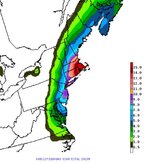
N-EAST_WRF_SFC_ACCUM-SNOWFALL_48HR.gif
 

billski

Active member
Joined
Feb 22, 2005
Messages
16,207
Points
38
Location
North Reading, Mass.
Website
ski.iabsi.com
This is getting better and better for me. Trend (NW) is my friend.

Even the Euro absolutely caved and is spitting out decent pcp now.

Also, IMO it doesnt seem like people are properly accounting for the artic air that should be locked in place. Seems most are conservatively using 15:1, but 17:1 or 18:1 etc... are definitely possible here. Maybe even 20:1 if we dare to dream.
I see where you're coming from now:
CONUS1_ETA212_SFC_ACCUMSNOWFALL-KUCHERA_72HR.gif


CONUS2_GFS0P5_SFC_ACCUM-SNOW_78HR.gif
 
Last edited:

Euler

Active member
Joined
Jan 28, 2007
Messages
1,063
Points
36
Location
Southern Vermont
I'm not sure I believe that number. Constableville, which isn't that far away is showing 102". It's not impossible, it just makes me want to look closer. Glad I could be of no help ;)
It's totally possible. Most of the snow is from lake effect which forms in narrow bands. I grew up in Watertown, NY and often one town on the Tugg Hill would get three feet, while 15 miles away another town would get a foot.
 
Joined
Sep 15, 2012
Messages
780
Points
16
Location
Boston
This is my intuition, but I'm thinking 8-14 east of rt 24, 6-8 inside of 495, 4-6 up to Pats Peak (possibly tickling Crotched) west to Wawa. 2-4 up to Sunapee, west to Okemo and 1-3 on north to the Whites, SR, Sugarbush. I'm probably wrong lol, just my 2 pennies.

Honestly, is BOX reading this thread? lol

StormTotalSnowFcst.jpg
 

wa-loaf

Well-known member
Joined
Jan 7, 2007
Messages
15,109
Points
48
Location
Mordor
Didn't really add up to much, but it snowed on and off all day at Pats today and was dumping pretty hard when I left. Probably be a good night session.
 

BenedictGomez

Well-known member
Joined
Jan 26, 2011
Messages
12,546
Points
113
Location
Wasatch Back
DT's final call map

1604928_635402856506976_2119743903_n.jpg


I could easily see these numbers being beaten if the trend continues. Trend is my friend!
 

MommaBear

Member
Joined
Nov 15, 2007
Messages
710
Points
18
Location
CT
My favorite was this past weekend when they had parts of.CT getting 1-2" and they got 10". These maps show it too.

I am just east of central CT and got a dusting to .5 inch. Was surprised to see the news last night showing parts of CT with a foot of snow!
 
Joined
Sep 15, 2012
Messages
780
Points
16
Location
Boston
I'm literally on pins and needles waiting for the GFS to see if it follows suit. 5-6 inches at SR would be mighty fine.
 
Top