• Welcome to AlpineZone, the largest online community of skiers and snowboarders in the Northeast!

    You may have to REGISTER before you can post. Registering is FREE, gets rid of the majority of advertisements, and lets you participate in giveaways and other AlpineZone events!

Winter Pattern Has Arrived - Will it Bring Snow?

catsup948

New member
Joined
Dec 6, 2007
Messages
1,026
Points
0
Location
Shelburne Falls, MA
Something will verify. When in great patterns like this something will happen. Dont look at each storm as modeled but look at all the ingredients that can lead to big storms. Im a plower from cnj so looking at the next month is making my pockets fat( hoping so at least). I am hoping at least a couple storms track north so ski country can get in on the fun. Strattons glades were a little hairy last weekend lol


Sent from my iPhone using AlpineZone

Right ingredients, right temperatures right time! Come on! This bitter cold snap is driving me crazy. We need snow and lots of it!

Sent from my SCH-I545 using Tapatalk
 

catsup948

New member
Joined
Dec 6, 2007
Messages
1,026
Points
0
Location
Shelburne Falls, MA
Cold is back. It was balmy yesterday here with highs in the mid 20s! Good snow making weather this week and things start heating up as soon as Friday. Several over running systems coming in. Snow to rain in the low lands and usually just snow up high. February the way it should be!

Sent from my SCH-I545 using Tapatalk
 

BenedictGomez

Well-known member
Joined
Jan 26, 2011
Messages
12,546
Points
113
Location
Wasatch Back
Two-week long-range models (which admittedly aren't the greatest) show COLD, COLD, more COLD, and pretty much COLD for at least the next 14 days they cover.
 
Joined
Sep 15, 2012
Messages
780
Points
16
Location
Boston
Models are showing a storm for Saturday, but they've been flip-flopping between a snowstorm and an Inside Runner. Little margin for error here.


Sent from my iPhone using AlpineZone
 

catsup948

New member
Joined
Dec 6, 2007
Messages
1,026
Points
0
Location
Shelburne Falls, MA
Good signs for a big event around 2/4-2/6. It's been there for awhile and it's on both the euro and gfs. The whole week leading up to the AZ summit is looking nice. Fingers crossed!

Sent from my SCH-I545 using Tapatalk
 

bigbog

Active member
Joined
Feb 17, 2004
Messages
4,882
Points
38
Location
Bangor and the state's woodlands
Unfortunately 2-4" in the mountainous playground of #128 doesn't make for much once it moves northeast...with an easterly kick, up the coast....for Maine. Has given the mountains of Bangor-Brewer...a few hours of intermittent(sp?) spitting of flakes...hope the true mountains get more but I'm skeptical. Who knows maybe we'll get a major dump on the 4th of July. Can remember my grandparents mentioning about that happenning up here one summer, sometime in the (19)20s....
On the Better News side...predicted temps for the SL area look a little more bearable...but still cold.
Just hope for little wind during the AZ invasion...
 
Last edited:
Joined
Sep 15, 2012
Messages
780
Points
16
Location
Boston
Radar looks great! Looks like there is some nice enhancement over the Whites and Greens right now.


Sent from my iPhone using AlpineZo
 
Joined
Sep 15, 2012
Messages
780
Points
16
Location
Boston
For early feb, latest GFS, GEFS, RGEM runs are showing two ski country specials, while the EURO is showing a full-blown rainstorm.

As a note, EURO is currently an outlier by a longshot.


Sent from my iPhone using AlpineZo
 

gladerider

Active member
Joined
Jan 2, 2005
Messages
1,125
Points
38
Location
NJ
If I remember correctly the Euro hasn't been too accurate for the last few storms. So crossing my fingers. ..

Sent from my SCH-I535 using Tapatalk
 

catsup948

New member
Joined
Dec 6, 2007
Messages
1,026
Points
0
Location
Shelburne Falls, MA
Toss the euro! It's been off lately. I would think outside a total cutters mountains of nne will reap the benefits of this pattern.

Sent from my SCH-I545 using Tapatalk
 

BenedictGomez

Well-known member
Joined
Jan 26, 2011
Messages
12,546
Points
113
Location
Wasatch Back
Talking about big snowstorms appearing on a model that's 9 days out is likley just setting people up for unnecessary disappointment.
 

catsup948

New member
Joined
Dec 6, 2007
Messages
1,026
Points
0
Location
Shelburne Falls, MA
Talking about big snowstorms appearing on a model that's 9 days out is likley just setting people up for unnecessary disappointment.

Maybe it is. I'm just talking overall pattern. It looks active and that is good. I'm neither hopeful nor doubtful this far out. I'm tired of all this cold.

Sent from my SCH-I545 using Tapatalk
 

Wavewheeler

New member
Joined
Feb 25, 2012
Messages
495
Points
0
Location
The Jersey Shore
Yes, but it would suck to have all this cold followed by yet another thaw and rain. I just wish we could settle into a nice, normal winter pattern of moderate cold/snow.
 
Joined
Sep 15, 2012
Messages
780
Points
16
Location
Boston
This is something good ?? yes ?

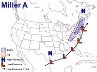
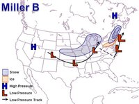
Very good. This is when an inland runner triple points at just the right time (Its cold front catches up to the warm front, cutting off the moisture and begins to weaken the system) and transfers its energy to a secondary coastal low off of the Mid Atlantic. These are usually snowy systems for us. (Think December 27, 2013, that was a classic Miller B)

BE WARNED: When Miller B's are modeled this far out, they very well could become a cutting rainstorm if the transfer doesn't occur at the right time.
 
Top