BeefyBoy50
New member
We need to keep the discussion threads coming with all the stoke that is going on.
I was thinking earlier about this because I have trail maps hanging on my walls.
I can spend a long time looking at certain trail maps, imagining I was skiing. Some are more absorbing than others and I can spend an hour looking at a map I already know without getting bored.
With that in mind, what are your favorite trail maps?
My favorite is possibly the Solitude trail map. Not sure why, but I think its beautifully drawn and the trail layout is interesting.
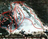
On the east coast I really like Killington's trail map because there is so much to look at.
I was thinking earlier about this because I have trail maps hanging on my walls.
I can spend a long time looking at certain trail maps, imagining I was skiing. Some are more absorbing than others and I can spend an hour looking at a map I already know without getting bored.
With that in mind, what are your favorite trail maps?
My favorite is possibly the Solitude trail map. Not sure why, but I think its beautifully drawn and the trail layout is interesting.
On the east coast I really like Killington's trail map because there is so much to look at.