• Welcome to AlpineZone, the largest online community of skiers and snowboarders in the Northeast!

    You may have to REGISTER before you can post. Registering is FREE, gets rid of the majority of advertisements, and lets you participate in giveaways and other AlpineZone events!

March 13th (Don't Crucify me!)

BenedictGomez

Well-known member
Joined
Jan 26, 2011
Messages
12,546
Points
113
Location
Wasatch Back
Well the EURO quelled my fears lol. I've been riding the EURO all the way with this storm, so why trust the GFS now.

I never trust the GFS. It's garbage compared to the Canadian and the Euro. It's like a new computer from 2014 versus a computer from 2007. IMO, with the upgrades this year the Canadian is now the best model. It has outperformed the Euro all winter, and the GFS has been a joke compared to either of them.
 

BenedictGomez

Well-known member
Joined
Jan 26, 2011
Messages
12,546
Points
113
Location
Wasatch Back
I love it when the first guesses start rolling in.

1617701_658956657484929_1176141827_o.jpg
 

BenedictGomez

Well-known member
Joined
Jan 26, 2011
Messages
12,546
Points
113
Location
Wasatch Back
Disclaimer - this map is not from a professional met, but from a group of college meteorology students. I just like their site, and besides, MOAR MAPS!!!!!!

1911198_206545406222771_652884295_o.png
 

wa-loaf

Well-known member
Joined
Jan 7, 2007
Messages
15,109
Points
48
Location
Mordor
Tim Kelly is pretty psyched about this one:

And he's talking about a St Pats day super storm?
 
Last edited:

octopus

Member
Joined
May 4, 2008
Messages
397
Points
16
Location
mass
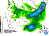
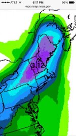
noaa putting out some pretty nice looking maps on fb. i got one shot for travel from boston on wed afternoon, where do i go?
 

flightschool

Member
Joined
Dec 29, 2013
Messages
91
Points
8
noaa putting out some pretty nice looking maps on fb. i got one shot for travel from boston on wed afternoon, where do i go?

If i had no pass and had to buy a ticket, I'de pick SR. It will be empty and its huge there will be perfect snow all day thursday.
 

octopus

Member
Joined
May 4, 2008
Messages
397
Points
16
Location
mass
flight,thats a good call, and sr always has a good base. magic is always awesome after a dump, but there might not be too much underneath
 

from_the_NEK

Active member
Joined
Jun 5, 2006
Messages
4,576
Points
38
Location
Lyndonville, VT
Website
fineartamerica.com
noaa putting out some pretty nice looking maps on fb. i got one shot for travel from boston on wed afternoon, where do i go?

You might want to pick somewhere that is less likely to have wind issues too. I'm hoping Burke's summit quad is running with the wind going straight up the lift line. But this thing is still going to be a cutter so what am I even talking about :D;)
 

CoolMike

New member
Joined
Oct 30, 2013
Messages
153
Points
0
Location
Pelham, NH
I'm pretty pumped right now. I'm not sure where I'm going but I'll be up in the mountains this weekend for sure! I've got a day pass at Bretton Woods I have to use but I'm also thinking about hitting Cannon, Sunday River, or Attitash.

Anyone been to Attitash lately? Do they have a decent base? I was there after a big storm (~11 inches) a few months ago and while it was lots of fun there was sketchy terrain everywhere. Grundel floss, shrubs, and exposed rocks littered the trails. Also, the water bars hadn't been groomed out, which was fun, but tiring because it made you do crazy jumps every 100 yards if you wanted to go fast.
 

MadMadWorld

Active member
Joined
Jan 10, 2012
Messages
4,082
Points
38
Location
Leominster, MA
You might want to pick somewhere that is less likely to have wind issues too. I'm hoping Burke's summit quad is running with the wind going straight up the lift line. But this thing is still going to be a cutter so what am I even talking about :D;)

Obviously nowhere in the NEK! Mountains with fixed grip chairlifts will be the way to go!
 

BenedictGomez

Well-known member
Joined
Jan 26, 2011
Messages
12,546
Points
113
Location
Wasatch Back
I booked for DAX. They're unlikely to be the jackpot zone, but given everyone north of the MA/VT border or so will likely win, and given the direction the cold air is coming from + timing issues, I decided to take: ice, mixing, rain 100% completely out of the picture. Gore on Saturday, Whiteface on Sunday for me.
 

billski

Active member
Joined
Feb 22, 2005
Messages
16,207
Points
38
Location
North Reading, Mass.
Website
ski.iabsi.com
you know where you're going...

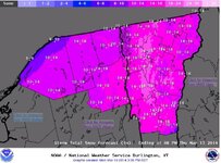
Here's the tech discussions, dumbed down so I can understand:

NWS Burlington, VT

[First Part - Wednesday]
SNOW RATIOS BTWN 10 AND 14 TO 1...... SOME HIGHER AMOUNTS NEAR 10" POSSIBLE ON THE SE UPSLOPE REGIONS OF THE GREEN MTNS FROM KILLINGTON TO STOWE AND EASTERN DACKS.

[Second Part]
THE 2ND PART IMPACTS OUR REGION LATE WEDS NIGHT INTO MOST OF THURSDAY AS GUSTY NORTH WINDS DEVELOP...OUR SNOW RATIOS ASSOCIATED BTWN 20 AND 30 TO 1.
COMBINED WITH HIGH FLUFF FACTOR SHOULD RESULT IN ADDITIONAL 6 TO 12 INCHES DACKS/NEK/CPV...AND 10 TO 16 INCHES WESTERN SLOPES.


SO ADDING BOTH PARTS TOGETHER RESULTS IN A WIDESPREAD 10 TO 20 INCH EVENT WITH LOCALIZED HIGHER AMOUNTS IN THE CENTRAL/NORTHERN GREEN MTNS BY
LATE THURSDAY.
 

billski

Active member
Joined
Feb 22, 2005
Messages
16,207
Points
38
Location
North Reading, Mass.
Website
ski.iabsi.com
NWS Grey Maine - NH forecast area
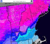
CONFIDENCE IS HIGHEST THAT PRECIPITATION WILL STAY ALL SNOW IN THE
FOOTHILLS AND MOUNTAINS... PERHAPS THE BIGGEST SNOWSTORM OF THE
SEASON FOR THESE AREAS.
 

billski

Active member
Joined
Feb 22, 2005
Messages
16,207
Points
38
Location
North Reading, Mass.
Website
ski.iabsi.com
NWS Albany
SENSIBLE WEATHER DETAILS...[their words, not mine]

WED/WED NIGHT...
PRECIP OVERSPREADS THE REGION FROM WEST TO
EAST...POSSIBLY HOLDING OFF UNTIL EARLY AFTERNOON OVER SOUTHEAST MA.
12Z MODEL GUIDANCE SUGGEST PRECIP MAY BEGIN AS SNOW SOMEWHERE ALONG
AND NORTH OF THE MASS PIKE AND INTO SOUTHERN NH...THEN THE RAIN-SNOW
LINE LIFTING NORTHWARD INTO SOUTHERN OR CENTRAL NH BEFORE CRASHING
SOUTHWARD WED NIGHT
BASED ON THE CURRENT STORM TRACK MOST
CONFIDENCE OF 6"+ ACROSS NORTHWEST INTO SOUTHWEST NH.

LESS SNOW SOUTHWARD BUT A RISK OF A WINTRY MIX FOR A TIME WED FROM
NORTHERN CT-RI TO THE MASS PIKE FOLLOWED BY A PERIOD OF WRAP AROUND
SNOW WED NIGHT INTO THU AM.

ELSEWHERE ACROSS MUCH OF CENTRAL-
SOUTHERN RI AND SOUTHEAST MA LITTLE IF ANY SNOWFALL EXPECTED ON THE
FRONT END WED WITH PERIODS OF HEAVY RAIN MORE OF A CONCERN.

WED NIGHT COULD BE SOME CONCERN REGARDING A FLASH FREEZE
 

wa-loaf

Well-known member
Joined
Jan 7, 2007
Messages
15,109
Points
48
Location
Mordor
Here's the tech discussions, dumbed down so I can understand:

NWS Burlington, VT

[First Part - Wednesday]
SNOW RATIOS BTWN 10 AND 14 TO 1...... SOME HIGHER AMOUNTS NEAR 10" POSSIBLE ON THE SE UPSLOPE REGIONS OF THE GREEN MTNS FROM KILLINGTON TO STOWE AND EASTERN DACKS.

[Second Part]
THE 2ND PART IMPACTS OUR REGION LATE WEDS NIGHT INTO MOST OF THURSDAY AS GUSTY NORTH WINDS DEVELOP...OUR SNOW RATIOS ASSOCIATED BTWN 20 AND 30 TO 1.
COMBINED WITH HIGH FLUFF FACTOR SHOULD RESULT IN ADDITIONAL 6 TO 12 INCHES DACKS/NEK/CPV...AND 10 TO 16 INCHES WESTERN SLOPES.


SO ADDING BOTH PARTS TOGETHER RESULTS IN A WIDESPREAD 10 TO 20 INCH EVENT WITH LOCALIZED HIGHER AMOUNTS IN THE CENTRAL/NORTHERN GREEN MTNS BY
LATE THURSDAY.

So a few inches of somewhat dense base with a nice layer of blower snow on top? Sounds good to me!
 
Top