• Welcome to AlpineZone, the largest online community of skiers and snowboarders in the Northeast!

    You may have to REGISTER before you can post. Registering is FREE, gets rid of the majority of advertisements, and lets you participate in giveaways and other AlpineZone events!

March 5 Storm?

BenedictGomez

Well-known member
Joined
Jan 26, 2011
Messages
12,546
Points
113
Location
Wasatch Back
NAM comes ridiculously far north.

I think it's a total BS run, but thought I'd post it for all the NE people here bitching.

1782319_203127076564604_580919807_o.png
 

BenedictGomez

Well-known member
Joined
Jan 26, 2011
Messages
12,546
Points
113
Location
Wasatch Back
View attachment 11476
Tally Ho!
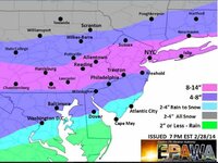
Also their Blog hinting at another storm!http://easternpaweatherauthority.com/

They're perhaps my favorite online weather outlet, but I dont get this map at this point, seems kindof high, and shifted a bit too far north. That said, they've done a great job and have been spot on all winter, but this map makes me wonder if they're sortof holding onto their first call map because they dont want to alter it. Either that, or maybe they're doing that because the general trend this winter has been for last minute northern shifts. I'll be pleased if this pans out though!
 

BenedictGomez

Well-known member
Joined
Jan 26, 2011
Messages
12,546
Points
113
Location
Wasatch Back
From Bastardi's offspring.

The best stuff would miss pretty much all of ski country, with the exception of a random place or two in WV. Speaking of which, while nobody ever talks about them, I bet they must be having their best ski season in.......well.......pretty much ever.

1978384_655887224468743_352085394_o.png
 
Joined
Sep 15, 2012
Messages
780
Points
16
Location
Boston
Sunny in NE per the GFS. DC is crushed and the Poconos get screwed again (2-4 inches)

Never good to have the PV directly overhead. Suppression depression.
 

BenedictGomez

Well-known member
Joined
Jan 26, 2011
Messages
12,546
Points
113
Location
Wasatch Back
If you take a look at the actual radar compared to where the models say the energy "should" be right now, I'm going to say it's a least 100 miles north of where it should be. Hopefully it stays there.
 

drjeff

Well-known member
Joined
Jan 18, 2006
Messages
19,400
Points
113
Location
Brooklyn, CT
If you take a look at the actual radar compared to where the models say the energy "should" be right now, I'm going to say it's a least 100 miles north of where it should be. Hopefully it stays there.

Real time observations.....

I woke up in Park City, UT today, worried about if I'd be able to make the drive down to SLC for my families 8:30 flight - it
 

billski

Active member
Joined
Feb 22, 2005
Messages
16,207
Points
38
Location
North Reading, Mass.
Website
ski.iabsi.com
If you take a look at the actual radar compared to where the models say the energy "should" be right now, I'm going to say it's a least 100 miles north of where it should be. Hopefully it stays there.
Man BG, you are really getting into this! I noticed you've signed up for a number of the for-fee web sites. They have some excellent renderings and it saves a lot of digging around. I'm still heading into VT tomorrow into Monday. The season doesn't get any longer. Go get yours in PA. Take a shovel ;)
 

BenedictGomez

Well-known member
Joined
Jan 26, 2011
Messages
12,546
Points
113
Location
Wasatch Back
Man BG, you are really getting into this!........ Go get yours in PA. Take a shovel ;)

I enjoy the speculation. Sadly, if the latest models are correct, there wont be that much to "get" in PA, as they've trended WAY south, to the point where DC and Baltimore are the bullseye instead of the Poconos. That said, unless my eyes are deceiving me, it seems like in "real life" it's already 100 miles north of where it's modeled. Time will tell.
 

Not Sure

Well-known member
Joined
Dec 14, 2013
Messages
2,859
Points
63
Location
Lehigh County Pa.
Website
www.youtube.com
Why are the numbers all over the place on this storm? Weather channel local says snow and rain 3-6 yet they show 12'' in DC?
Eastern Pa. Blog has a new map showing a southern shift but metions a strong southerly flow and things may reverse and shift North ....Suspense!Arrrrrrg!
 
Last edited:

BenedictGomez

Well-known member
Joined
Jan 26, 2011
Messages
12,546
Points
113
Location
Wasatch Back
Seems gone now, calling for 1 to 3 for north jersey and a dusting for the cats. Boy that was a turnaround.

Death by 1000 cuts with every model run for a while drifting 10 or 20 miles south.

BUT, if the models are all overestimating the PV or underestimating the southern stream, there's still a chance for decent snow. To add confusion to the fire, after being the most southern run all week long, the Canuck came decently north tonight, lol.
 

Abominable

Active member
Joined
Jan 18, 2013
Messages
491
Points
28
At magic today, groomers are fun but limited. Groomers at Stratton Friday and bromley yesterday were fast and fun, but moguls never softened despite the sun and woods are scratchy but good base. Point being, even six inches could open things up nicely. Make it so!


Sent from my iPhone using AlpineZone
 

catsup948

New member
Joined
Dec 6, 2007
Messages
1,026
Points
0
Location
Shelburne Falls, MA
Cold week upcoming but pattern seems to change next weekend to more seasonable. Throw in some precipitation and see what happens in the mountains.

Sent from my SCH-I545 using Tapatalk
 

Tin

Active member
Joined
Oct 14, 2009
Messages
2,996
Points
38
Location
ZooMass Slamherst
This winter is turning out to be pretty crappy in terms of snow conditions. Crotched was bulletproof bumps and woods yesterday.
 

xwhaler

Active member
Joined
Nov 26, 2007
Messages
2,943
Points
38
Location
Seacoast NH
Snowed most of the AM at Okemo. Didn't amount to too much but it made the surfaces quite nice I thought
 

skiking4

Member
Joined
Dec 9, 2012
Messages
166
Points
16
Seems to be a winter of consistently good groomer skiing. Any good dump seems to be followed by rain soon after and then a long cold dry spell to freshen up the groomers.
 
Top