-
Welcome to AlpineZone, the largest online community of skiers and snowboarders in the Northeast!
You may have to REGISTER before you can post. Registering is FREE, gets rid of the majority of advertisements, and lets you participate in giveaways and other AlpineZone events!
You are using an out of date browser. It may not display this or other websites correctly.
You should upgrade or use an alternative browser.
You should upgrade or use an alternative browser.
Weekend of December 14th
- Thread starter billski
- Start date
St. Bear
New member
I'll take a couple trails of powder. And if they open anything else, all the better.
buellski
New member
from_the_NEK
Active member
The noontime run of the GFS looks to be taking the storm offshore... Figures  uke:
uke:
4aprice
Well-known member
The noontime run of the GFS looks to be taking the storm offshore... Figuresuke:
Almost makes me think it will definitely happen now. Gfs is known to lose things at this range and then bring them back (I trust the Euro more). I just have a hunch that there will be a decent storm because its the perfect time of the year for it around here. December 1992 comes to mind.
Alex
Lake Hopatcong, NJ
skiberg
Member
- Joined
- Sep 28, 2010
- Messages
- 588
- Points
- 18
NWS post on NEK weather does not seem that concerned. They note difference, but it seems only as to how much. Models are in agreement as to storm just not exact track yet.
billski
Active member
WFO-BOSTON
ITS WAY TOO EARLY FOR SPECIFIC AMOUNTS BUT GIVEN THE MAGNITUDE AND
ORIGINS OF THE COLD AIR OVER NEW ENGLAND BEFORE THE STORM ARRIVES
COMBINED WITH COPIOUS SOUTHERN STREAM MOISTURE...SIGNIFICANT SNOW
AND ICE ARE POSSIBLE BEFORE ANY CHANGEOVER. GIVEN THE TIME RANGE
HERE WE WILL BASE THIS FORECAST ON A SUPER BLEND OF ENSEMBLES/
DETERMINISTIC GUIDANCE ALONG WITH OUR PREVIOUS FORECAST. THIS YIELDS
A MODERATE TO HIGH RISK OF SIGNIFICANT SNOW AND ICE FOR MUCH OF
SOUTHERN NEW ENGLAND...WITH HIGHEST RISK ACROSS THE INTERIOR. EVEN
CLOSER TO THE COAST INCLUDING THE BOSTON-PROVIDENCE CORRIDOR A
PERIOD OF SIGNIFICANT SNOW AND ICE /FRONT END THUMP/ IS POSSIBLE
BEFORE ANY CHANGEOVER. STAY TUNED TO LATER FORECASTS AND
DISCUSSIONS!
billski
Active member
NWS post on NEK weather does not seem that concerned. They note difference, but it seems only as to how much. Models are in agreement as to storm just not exact track yet.
The growing consensus is that the bulk of the storm will not track that far north.
billski
Active member
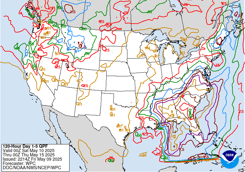
Blue line represents 1" QPF, which would be about 10-12 of fluff, deeper inside the blue, the purple represents 1.5" QPF.


Last edited:
billski
Active member
The noontime run of the GFS looks to be taking the storm offshore... Figuresuke:
Somewhat offshore is good, gets us into the "noreaster" pattern.
skiberg
Member
- Joined
- Sep 28, 2010
- Messages
- 588
- Points
- 18
Sounds like the general consensus is overall good for most of NE
WFO-BOSTON
ITS WAY TOO EARLY FOR SPECIFIC AMOUNTS BUT GIVEN THE MAGNITUDE AND
ORIGINS OF THE COLD AIR OVER NEW ENGLAND BEFORE THE STORM ARRIVES
COMBINED WITH COPIOUS SOUTHERN STREAM MOISTURE...SIGNIFICANT SNOW
AND ICE ARE POSSIBLE BEFORE ANY CHANGEOVER. GIVEN THE TIME RANGE
HERE WE WILL BASE THIS FORECAST ON A SUPER BLEND OF ENSEMBLES/
DETERMINISTIC GUIDANCE ALONG WITH OUR PREVIOUS FORECAST. THIS YIELDS
A MODERATE TO HIGH RISK OF SIGNIFICANT SNOW AND ICE FOR MUCH OF
SOUTHERN NEW ENGLAND...WITH HIGHEST RISK ACROSS THE INTERIOR. EVEN
CLOSER TO THE COAST INCLUDING THE BOSTON-PROVIDENCE CORRIDOR A
PERIOD OF SIGNIFICANT SNOW AND ICE /FRONT END THUMP/ IS POSSIBLE
BEFORE ANY CHANGEOVER. STAY TUNED TO LATER FORECASTS AND
DISCUSSIONS!
Front end thump, hehehehe
from_the_NEK
Active member
Well, hopefully we get at least enough to shovel.
billski
Active member
Last two runs of the models are snowing less precip. 
skiberg
Member
- Joined
- Sep 28, 2010
- Messages
- 588
- Points
- 18
I saw the same thing. Looks like they are calling for potential of 3-6 or 4-8 inches, not the foot plus we were hoping for.
dlague
Active member
This is how things have been shaping up so far
last storm 2-5 inches = dusting
around Thanksgiving 3-4 inches of snow or more = rain
just before Halloween snow predicted = rain
now = reduced numbers which will probably be lowered more!
last storm 2-5 inches = dusting
around Thanksgiving 3-4 inches of snow or more = rain
just before Halloween snow predicted = rain
now = reduced numbers which will probably be lowered more!
WWF-VT
Well-known member
Gary says 3-6" from Saturday into Sunday in VT, but it's still early to call:
http://www.wcax.com/category/166239/video-landing-page?clipId=9622673&autostart=true
http://www.wcax.com/category/166239/video-landing-page?clipId=9622673&autostart=true
skiberg
Member
- Joined
- Sep 28, 2010
- Messages
- 588
- Points
- 18
He said "at least"; thank god. I am still praying to Ullr.
Tin
Active member
I could do my PhD on the psychology of skiers before a big storm. Seems like 3 phases...
-Prestorm Hype: (5-7 days out) Models show huge dump (no Freudian thing here though) when everyone is manic/hypomanic
-Middlestorm: (2-4 days out) Models show a little less and some depressive symptoms kick in
-Prior Storm: (2 days to storm) Models show the same amount as in middle storm or prestorm phase and everyone goes back to mania/hypomania
Similar threads
- Replies
- 51
- Views
- 11K
- Replies
- 0
- Views
- 397